

Ijraset Journal For Research in Applied Science and Engineering Technology
Analysis and Providing Solutions for the Rectification of Black Spots On NH-27(OLD NH-28)
Authors: Vishal Pandey, Harivansh Kumar Chaudhary, Akash Malik
DOI Link: https://doi.org/10.22214/ijraset.2022.47002
Certificate: View Certificate
Abstract
This study primarily based totally on the road safety and specified observe of black spot. National highways represent a considerable percentage of these accidents, especially during the massive economic loss and exaggerates the development of the country. Basically the main aim of this paper is to Identify the black spot and more elaborated study for Analysis of Black Spots and its Rectification on the basis of traffic survey i.e. by Turning Movement Count survey. This study includes different approaches and methods that are used for Selection of particular study stretch i.e. NH-27, firstly collection of accident data and then we split down the data for better observation for the analysis of black spot also we throw light on the causes which are responsible for accident on the basis of ASI (Accident severity index). Also, it consists of a few strategies which might be used to profile those accident places and the usage of earlier than and after research to estimate the impact of remedy at the Black spots or dark spot on highway. This paper concludes the rectification methodology based on short term measurements, long term measurements, mitigation measures or geometric design improvement which depend on existing road conditions
Introduction
I. INTRODUCTION & LITERATURE REVIEW
India is in a race of developing country and increase in road network in India growing rapidly. According to the India’s Basic Road Statistics, India has the second largest road network in the world. The alarming increase in road accidents is one of India's least well-kept secrets. The number of serious and minor injuries, human suffering and economic damage from accidents is inestimable. Road safety is therefore a major concern in the current situation. According to traffic accident data released in 2019 by the Ministry of Road and Motorway Transport, a total of 449,002 accidents occurred in the country in the 2019 calendar year, with 151,113 fatalities and 451,361 injuries. This analysis shows that approx. 1,374 accidents i.e. 377 deaths occur every day. These disturbing statistics only shows the lack of appropriate road safety measures in the country. As per Ministry of Road Transport and Highway (MORTH) the Road Accident Black Spot is a stretch of National Highway in which 10 fatalities took place the last 3 calendar years or 5 road accidents at 500m distance (including fatalities/grievous injuries in totally 3 years) took place during the last 3 calendar years. To provide the solutions for reducing the severity or we can say removal of any black spot is very much needed therefore in order to understand the characteristics and the volume of traffic at any particular black spot on highway road network it is important to conduct a traffic survey at that particular black spot (Here we are using Turning Movement Count Survey) because reduction of black spot from highway is one of the maximum essential problems concerning lack of life. The selected project Study Area is stretches of National Highways of Mehsi- Muzaffarpur Section from km 440.00 to km 520.00 (Total Length 80.00 Km) of NH-27 (old NH- 28) in the State of Bihar Therefore, the fundamental intention of the task is to providing measures for the rectification of Black spots identified on NH-27. After Studying, Examining & Analyzing Black spots we can be rectify and decrease appreciably after implementation of quick time period measures. Nikhil Katre, N. H. Pitale, Shrikant Bobade (2019) aimed at the rectification of different black spots on the basis of short term, long term, mitigation measure or improvement of geometric design required as per existing road condition [1]. Athira Mohan Dr. V.S. Landge (2017)) aim to identify the Black Spot location along Amravati to Nagpur road stretch on Asian Highway 46 on the basis of Weighted Severity Index [2]. R.R. Sorate1, R.P. Kulkarni2, S.U. Bobade3, M.S. Patil4, A.M. Talathi4, I.Y. Sayyad4, S.V. Apte4(2015) hinted at various methods adopted to identify the causes of accidents also to identify the Black Spot on National Highway 4 [3]. Arnav Duarah, Abinash Kashyap, Kapil Katuwal, Manoj Kumar Sarma, Sushmita Borah, Raj Chakrabarty (2017) aim to identify Black Spot on NH-27 by comparing 3 different methods i.e. accident rate, accident frequency & Weighted Severity Index [4]. LIU Yichao (2013) aimed at prevention of accident black spots by deep study on different influence factors responsible for accident Black Spot formation on National Highways [5]. After analyzing the different studies and researches we came to know about the methods and different solutions for the rectification of black spots now in this study we are using it for rectification of different black spots pre-identified on study stretch.
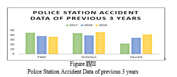
This study methodology includes the process of providing the solution for the rectification of some particular black spots chosen from the list of black spots identified on the study stretch.
- In this study the selected study stretch is located in state of Bihar, India i.e. From Kotwa to Muzzafarpur which is approx. 81.2 Km on NH-27 (old NH-28)
- Study stretch as per chainage allotted by NHAI (National Highway Authority of India) is National Highways of Mehsi- Muzaffarpur Section from km 440.00 to km 520.00 (Total Length 80.00 Km) of NH-27 (old NH- 28) in the State of Bihar.
- Previous 3-year road accident data was collected from the respective police stations for the rectification of Black spots.
- Bifurcation of Road accident data as per the type of injury (i.e. Fatal, Grievous or Minor) or sometimes Nature of accident.
- As per the bifurcated data of police station accident record, we pick some spots out of different existing black spots according to the maximum accident occurring on selected stretch for conducting the analysis of black spots for further rectification solutions.
- Selected spots then get analyzed by the ASI (Accident Severity Index) to priorities the black spots identified according to importance of solution required.
- For the detailed analysis of selected black spots, we conduct Traffic survey (Here we are using Turning Movement Count Survey).
- Through TMC Survey we can understand the volume of traffic and type of vehicle using that particular black spot on that study stretch corridor.
- We can choose the solutions for the rectification on selected black spots on our study stretch through detailed study of ASI (Accident severity index) and TMC (Turning Movement Count) data.
- Providing proper safety measures for the rectification of black spot.
- At last reduction in number of accident took place after the implementation of rectification solution for the selected black spots.
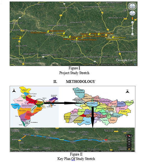
III. STUDY AREA
Study area selected stretch of National Highway of Mehsi- Muzaffarpur Section from km 440.00 to km 520.00 (Total Length 80.00 Km) of NH-27 (old NH- 28) in the State of Bihar, India taken by google earth.
Primarily data of existing black spots on NH-27 get collected from MORTH & NHAI.
TABLE II
Black Spot Locations On NH-27
|
Sr. No. |
Police station included |
Black Spot Location identified by MORTH & NHAI on NH-27 |
Chainage as per NHAI |
|
1 |
Chakia Police station |
Banjhula Chowk |
470.05 |
|
2 |
Chakia Police station |
Baragi Bazaar Market Area |
487.65 |
|
3 |
Motipur Police station |
Kali Mandir Motipur |
492.80 |
|
4 |
Motipur Police station |
Pansalwa Chowk Market Area |
497.40 |
|
5 |
Motipur Police station |
Narriyar Area |
499.30 |
|
6 |
Meenapur Police station |
Kharika Chawk |
503.52 |
|
7 |
Kanti Thermal Police station |
Chinmastika Mandir |
508.87 |
|
8 |
Kanti Thermal Police station |
Near Kanti Thermal |
509.58 |
|
9 |
Kanti Thermal Police station |
Near Netaji Chowk |
510.60 |
IV. STATISTICAL ANALYSIS AND OBSERVATIONS
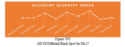
Police station accident data (Bifurcated) record of previous 3 years for the analysis.
TABLE IIII
Police Station Accident Data
|
BIFURCATED POLICE STATION ACCIDENT DATA OF 3 YEARS |
||||||||||||||||||
|
Location |
2017 |
2018 |
2019 |
|||||||||||||||
|
Fatal |
Grievous |
Injured |
Fatal |
Grievous |
Injured |
Fatal |
Grievous |
Injured |
||||||||||
|
M |
F |
M |
F |
M |
F |
M |
F |
M |
F |
M |
F |
M |
F |
M |
F |
M |
F |
|
|
1 |
3 |
2 |
4 |
2 |
2 |
0 |
2 |
4 |
2 |
1 |
3 |
2 |
4 |
3 |
4 |
4 |
5 |
1 |
|
2 |
5 |
2 |
1 |
0 |
1 |
0 |
6 |
1 |
3 |
1 |
4 |
1 |
1 |
2 |
2 |
2 |
2 |
3 |
|
3 |
9 |
4 |
6 |
8 |
1 |
2 |
4 |
6 |
4 |
6 |
7 |
4 |
7 |
4 |
8 |
8 |
4 |
5 |
|
4 |
2 |
1 |
3 |
4 |
5 |
1 |
3 |
4 |
2 |
1 |
2 |
2 |
2 |
2 |
6 |
5 |
3 |
1 |
|
5 |
6 |
8 |
8 |
4 |
3 |
2 |
9 |
8 |
6 |
3 |
6 |
3 |
4 |
6 |
10 |
9 |
6 |
1 |
|
6 |
4 |
6 |
7 |
2 |
1 |
0 |
2 |
3 |
4 |
4 |
4 |
3 |
5 |
1 |
8 |
5 |
7 |
2 |
|
7 |
8 |
6 |
11 |
5 |
6 |
1 |
9 |
6 |
8 |
7 |
3 |
2 |
6 |
7 |
5 |
6 |
8 |
3 |
|
8 |
4 |
3 |
2 |
3 |
2 |
1 |
1 |
4 |
4 |
5 |
3 |
4 |
2 |
2 |
2 |
6 |
2 |
2 |
|
9 |
4 |
2 |
2 |
4 |
1 |
1 |
2 |
1 |
6 |
7 |
2 |
3 |
5 |
3 |
1 |
4 |
4 |
1 |
|
Total |
45 |
44 |
22 |
38 |
39 |
34 |
36 |
46 |
41 |
|||||||||
|
Where, M= Male |
||||||||||||||||||
|
F= Female |
||||||||||||||||||
Based on police station accident data record for the analysis of black spots Accident Severity Index (ASI) value was calculated. ASI is that value which indicates the hazardous of any location, following equation has been used for the ASI chart:
ASI = [(Nf*Wf) +(Ng*Wg) +(Ni*Wi)] ………. (1)
Where,
Nf - No. of fatal accidents occur in last 3 years
Wf - Weight assign to fatal accident (here we use 6)
Ng - No. of grievous accidents occur in last 3 years
Wg - Weight assign to grievous accident (here we use 3)
Ni - No. of injured accident occur in last 3 years
Wi - Weight assign to Injured accident (here we use 1)
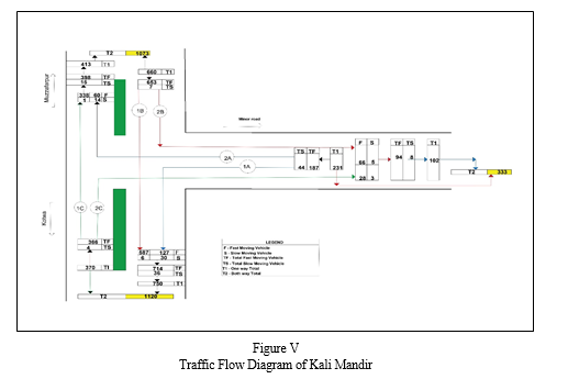
TABLE VII
ASI Value as Per Equation 1
|
Accident Severity Index of Black Spots on NH- 27 |
|
|
Location |
Accident Severity Index |
|
Banjhula Chowk |
94 |
|
Baragi Bazaar Market Area |
97 |
|
Kali Mandir Motipur |
186 |
|
Pansalwa Chowk Market Area |
85 |
|
Narriyar Area |
201 |
|
Kharika Chawk |
135 |
|
Chinmastika Mandir |
227 |
|
Near Kanti Thermal |
73 |
|
Near Netaji Chowk |
100 |
Based on ASI values the highest valued black spots further be taken for the rectification solution analysis i.e. Kali Mandir Motipur, Narriyar area & Chinmastika Mandir.
A. For the selected black spots, we will do traffic survey for addressing various objectives and issues pertaining rectification of blackspot.
B. Here we are using Turning Movement Count Survey in order to understand the characteristics and the volume of traffic using the project road stretch, data on existing road network, traffic volume on the project road were collected through this traffic survey.
- Turning Movement Count Survey Analysis
Kali Mandir Motipur at chainage 492.80
The intersection peak hour traffic (in number and in PCU) of Kali Mandir Motipur has been shown in table IV.
TABLE VIIV
|
Peak Hour |
Direction |
Total Motorised Vehicles |
Total Non-motorised Vehicles |
Total Motorised + |
|||||
|
Code |
Description |
||||||||
|
From |
To |
No. |
PCU |
No. |
PCU |
No. |
PCU |
||
|
10 |
11 |
1A |
Minor Road to Kotwa |
127 |
101 |
30 |
15 |
157 |
116 |
|
1B |
Muzaffarpur to Kotwa |
587 |
707 |
6 |
3 |
593 |
710 |
||
|
2A |
Minor Road to Muzaffarpur |
60 |
45 |
14 |
7 |
74 |
52 |
||
|
2B |
Muzzafarpur to Minor road |
66 |
71 |
5 |
3 |
71 |
74 |
||
|
1C |
Kotwa to Muzaffarpur |
338 |
344 |
1 |
1 |
339 |
344 |
||
|
2C |
Kotwa to Minor road |
28 |
29 |
3 |
2 |
31 |
31 |
||
|
Total Peak Hour Data |
1265 |
1325 |
|||||||
2. Observation & Proposed Solution
a. It has been observed that parked trucks causing congestion to the vehicles on right side of carriage way while driving into the minor lane.
b. There has been a disorientation in channelizing island diverting traffic to wrong side at channelizing area at the median opening.
c. A VUP with span of 12.0m with vertical clearance of 5.5m.
d. Provision of a Truck-lay bay with 20 truck parking capacity.
e. Provision of intermediate lane, service road on both side of main carriageway.
f. Development of Entry/Exit at the start/end of service road.
g. Provision of signage as per IRC:67-2012.
h. Provision of Lane marking as per IRC:35-2015.
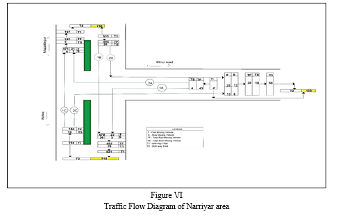
Narriyar area at chainage 499.30
The intersection peak hour traffic (in number and in PCU) of Narriyar area has been shown in table V.
TABLE V
|
Peak Hour |
Direction |
Total Motorised Vehicles |
Total Non-motorised Vehicles |
Total Motorised + |
|||||
|
Code |
Description |
||||||||
|
From |
To |
No. |
PCU |
No. |
PCU |
No. |
PCU |
||
|
17 |
18 |
1A |
Minor Road to Kotwa |
22 |
14 |
3 |
2 |
25 |
15 |
|
1B |
Muzaffarpur to Kotwa |
470 |
735 |
26 |
13 |
496 |
748 |
||
|
2A |
Minor Road to Muzaffarpur |
21 |
12 |
1 |
1 |
22 |
13 |
||
|
2B |
Muzzafarpur to Minor road |
25 |
19 |
12 |
6 |
37 |
25 |
||
|
1C |
Kotwa to Muzaffarpur |
171 |
212 |
4 |
2 |
175 |
214 |
||
|
2C |
Kotwa to Minor road |
13 |
14 |
6 |
3 |
19 |
17 |
||
|
Total Peak Hour Data |
774 |
1031 |
|||||||
3. Observation & Proposed Solution
a. It has been observed that parked trucks causing congestion to the vehicles on right side of carriage way while driving into the minor lane.
b. There has been a disorientation in channelizing island diverting traffic to wrong side at channelizing area at the median opening.
c. A VUP with span of 12.0m with vertical clearance of 5.5m.
d. Provision of a Truck-lay bay with 20 truck parking capacity.
e. Provision of intermediate lane, service road on both side of main carriageway.
f. Development of Entry/Exit at the start/end of service road.
g. Provision of signage as per IRC:67-2012.
h. Provision of Lane marking as per IRC:35-2015.
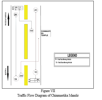
4. Chinmastika mandir at chainage 508.87
The intersection peak hour traffic (in number and in PCU) of Chinmastika Mandir has been shown in table VI.
TABLE VI
|
Peak Hour |
Direction |
Total Motorised Vehicles |
Total Non-motorised Vehicles |
Total Motorised + |
|||||
|
Code |
Description |
||||||||
|
From |
To |
No. |
PCU |
No. |
PCU |
No. |
PCU |
||
|
16 |
17 |
1W |
Temple to Muzaffarpur |
2 |
1 |
4 |
2 |
6 |
3 |
|
1B |
Kotwa to muzzafarpur |
574 |
686 |
0 |
0 |
574 |
686 |
||
|
2W |
Kotwa to Temple |
1 |
1 |
0 |
0 |
1 |
1 |
||
|
2B |
Kotwa to Muzaffarpur |
574 |
686 |
3 |
2 |
577 |
688 |
||
|
1C |
Muzaffarpur to Kotwa |
398 |
459 |
1 |
1 |
399 |
460 |
||
|
2C |
Muzaffarpur to Kotwa |
398 |
459 |
1 |
1 |
399 |
460 |
||
|
Total Peak Hour Data |
1956 |
2296 |
|||||||
5. Observation & Proposed Solution
a. It is observed that median opening is placed 100m away from the temple, forcing vehicle users to take wrong route to the temple.
b. It is observed that there is on-street parking available for the temple.
c. A LVUP with span of 7.0m with vertical clearance of 4.0m.
d. Provision of a Truck-lay bay with 20 truck parking capacity.
e. Provision of intermediate lane, service road on both side of main carriageway.
f. Development of Entry/Exit at the start/end of service road.
g. Provision of signage as per IRC:67-2012.
h. Provision of Lane marking as per IRC:35-2015.
Conclusion
From the project stretch it\'s been observed that providing the solutions for the rectification of black spots, the intention does now no longer best determine what assets are wanted however additionally have an effect on which quick time period measures must be applied, since rectification of Black Spot is endless process or we can say it’s a continuous process due to variety of different reasons for any on road accidents and every Black spot require some other kind of analysis to solve the problem and here in this study we choose Accident Severity Index (ASI) and Turning Movement Count (TMC) method to provide the solutions for rectification of different pre-existing which are concluded as follows: 1) Basic aim of this project is to provide the solution for the rectification of different identified black spots with the use of traffic survey method on NH-27 (old NH-28). 2) In this study we are using existing police station accident data record to understand the severity rate of different black spots identified by Ministry of Road Transport and Highway Also National Highway Authority of India. 3) On the basis of ASI (Accident Severity Index) we came to know that from the given list of black spots few of them appeared to be most hazardous as compared to others and need to be rectified on priority basis. 4) Solution for rectification has been given at the end of the analysis of data as long term measure for black spots also for safer use of intersections. 5) In last black spots will be rectify after the implementation of safety measures on NH-27.
References
[1] Katre, N., Pitale, N. H., & Bobade, S. (2019) Analysis of Black Spots on NH-3 and Its Rectification. Journal of Transportation Systems, 4(2). [2] Mohan, A., & Landge, V. S. (2017). Identification of accident black spots on national highway. Int. J. Civ. Eng. Technol, 8(4), 588-596. [3] Sorate, R. R., Kulkarni, R. P., Bobade, S. U., Patil, M. S., Talathi, A. M., Sayyad, I. Y., & Apte, S. V. (2015). Identification of accident black spots on national highway 4 (New Katraj tunnel to Chandani chowk). IOSR Journal of Mechanical and Civil Engineering (IOSR-JMCE), 12(3), 61-67. [4] Duarah, A., Kashyap, A., Katuwal, K., Sarma, M. K., Borah, S., & Chakrabarty, R. (2017) Determination of Blackspot on National Highway-37 (New NH-27), Assam. [5] Liu, Y. (2013). Highway traffic accident black spot analysis of influencing factors. In ICTE 2013: Safety, Speediness, Intelligence, Low-Carbon, Innovation (pp. 2295-2300). [6] Roess, R. P., Prassas, E. S., & McShane, W. R. (2004). Traffic engineering. Pearson/Prentice Hall. [7] Elena, K., Sergei, E., & Jaros?aw, R. (2020). Potential for improving the procedure of inspecting road traffic accident black spots. Architecture and Engineering, 5(3), 56-62. [8] Dereli, M. A., & Erdogan, S. (2017). A new model for determining the traffic accident black spots using GIS-aided spatial statistical methods. Transportation Research Part A: Policy and Practice, 103, 106-117. [9] Elena, K., Sergei, E., & Grigory, G. (2020). Systemic indicators of road infrastructure at accident clusters. Architecture and Engineering, 5(1). [10] Shad, R., & Rahimi, S. (2017). Identification of road crash black-sites using geographical information system. International Journal for Traffic and Transport Engineering,7(3),368-380.
Copyright
Copyright © 2022 Vishal Pandey, Harivansh Kumar Chaudhary, Akash Malik. This is an open access article distributed under the Creative Commons Attribution License, which permits unrestricted use, distribution, and reproduction in any medium, provided the original work is properly cited.

Download Paper
Paper Id : IJRASET47002
Publish Date : 2022-10-07
ISSN : 2321-9653
Publisher Name : IJRASET
DOI Link : Click Here
 Submit Paper Online