

Ijraset Journal For Research in Applied Science and Engineering Technology
Detection of Land Use and Land Cover Change in Jammu District using Remote Sensing and GIS Techniques
Authors: Prof. Dr. Sanjeev Kumar Gupta, Anoop Kumar, Shivwant Kumar, Aman Singh, Sandeep Singh
DOI Link: https://doi.org/10.22214/ijraset.2023.55129
Certificate: View Certificate
Abstract
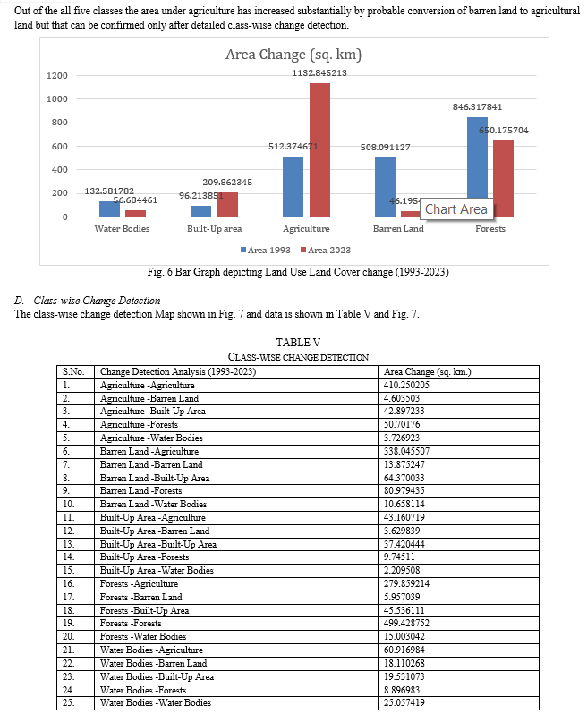
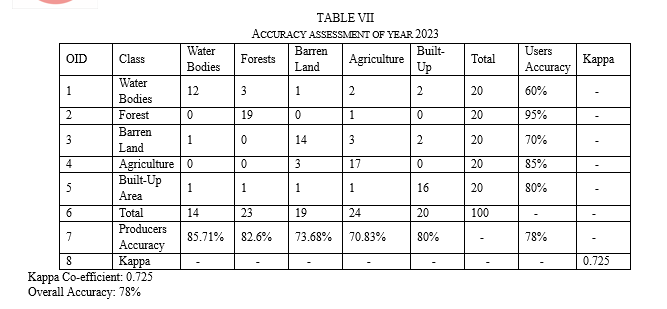
Jammu District has under gone a massive change in its land use and land cover in last 30 years. It has grown 2.5 times in its population in past 3 decades and simultaneously the infrastructure supporting the population growth has increased altering the overall land cover. With the growing population the demand for arable land, infrastructure development, land resource management becomes an obligation for effective optimization of resources and policy formulation and implementation. In this research the land use land cover change detection and analysis in last 30 years from 1993 to 2023 is attempted for the first time. The classification is achieved by supervised image classification of Landsat 5 and Landsat 9 Level 1 imagery acquired from USGS. The classification scheme is developed for five classes viz. Water Bodies, Built-Up Area, Agriculture, Barren Land and Forests. Change detected is -3% for water bodies, +5% for built-up area, +29 % for agricultural land, -22% for barren land, -9% for forest cover. The percentages are calculated of the total area. The overall accuracy is maintained at 87% for year 1993 and 78% for year 2023.
Introduction
I. INTRODUCTION
In past 100 years of rapid urbanization and anthropogenic action, the earth surface has undergone a drastic change. With increase in population, human settlements have increased, forest cover has decreased and a substantial area has been converted to agriculture to meet the demands of growing population. Similarly, the Water Bodies such as Lakes, Rivers and Wetlands have also shrunk due to human encroachment and increased water demands. All the resources on Earth are overstretched to meet the increasing demands, causing a massive change on earth’s surface.
Such a rapid and unsustainable change on earth surface requires effective Planning and Monitoring to access its impact on environment and plan its mitigation. Conventionally, physical surveys were done to calculate the areas of Forest, Agricultural Land and Settlements and calculate their change from time to time. But such surveys are time and resource intensive and are prone to errors when extended to large areas. To solve this remote sensing and GIS techniques can be employed to map earth’s surface, analyze data and create scientific models which can be helpful in understanding the different land classes.
In India there is only 2.3 % of terrestrial land area, while it has 17% of the global population and 11% of the global livestock. The pressure on the Indian land mass is almost 4-6 times the global average. In the last 40 years the area under crop has almost remained constant at around 140±2.0 Mha (Roy and Murthy, 2009). To sustain the ever-increasing population there is need of intensive agriculture, which annually withdraws around 2000-2500 x 106 m³ of water, thereby putting a stretch on existing water resources. In view of all this, due attention has to be given to develop national policies of various sectors of land management that involves Land Use change detection.
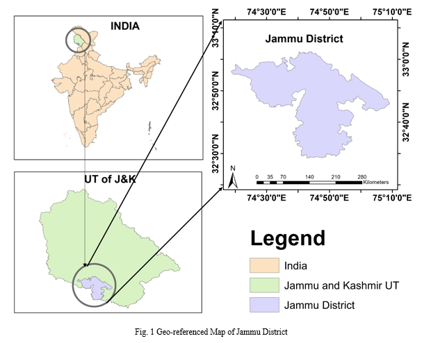
II. STUDY AREA
The study area of Jammu is Winter Capital of Union Territory of Jammu and Kashmir. It is situated between 32° 55' and 33° 45' north latitude and 74° 33' and 75° 23' east longitude. The district consists of both plains and hilly terrain. Tawi River and a major tributary of Chenab are major water resources which flow through it.
The plains of Jammu city, located in the southern part of the district, are relatively flat and fertile. These plains are suitable for agriculture and are utilized for the cultivation of crops such as wheat, rice, maize, pulses, and vegetables. The agricultural activities in the plains contribute significantly to the local economy.
The terrain of northern part is majorly hilly. It is surrounded by hills and mountains, forming part of the Shivalik Range. The forest cover is habitat for diverse flora and fauna.
III. OBJECTIVES
The following specific objectives are pursued in this research order to achieve the aim:
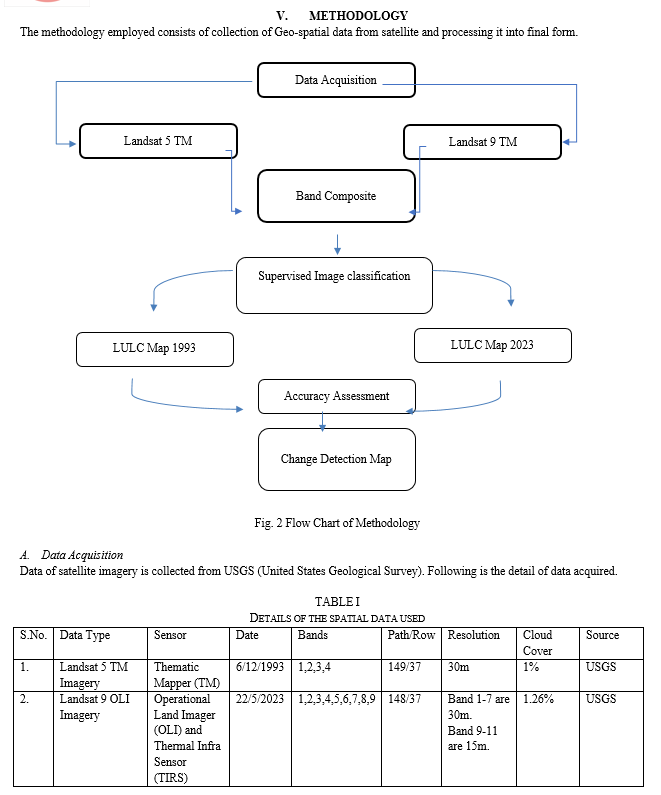
- To create a land use and land cover map of 1993 using Landsat-4 MS imagery.
- To create a land use and land cover map of 2023 using Landsat-9 TM imagery.
- To create geo-referenced Shape file of Jammu District by digitizing physical map.
- To perform accuracy assessment of the created maps.
- To create Change Detection Map depicting change in different classes in 30 years.
- To calculate the area under each of the land classes and calculate the area converted from one class to another.
- To analyze the LULC change data.
IV. JUSTIFICATION OF RESEARCH
The population of District Jammu has grown by 200% in last 3 decades and to support the growing population the infrastructure has also developed, altering the existing the land use/land cover of the district. Hence, a comprehensive research is required to be done to map the changes in various classes of land and study its impact.
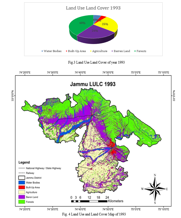
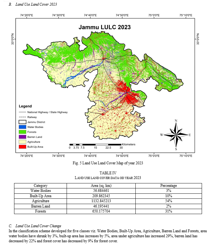
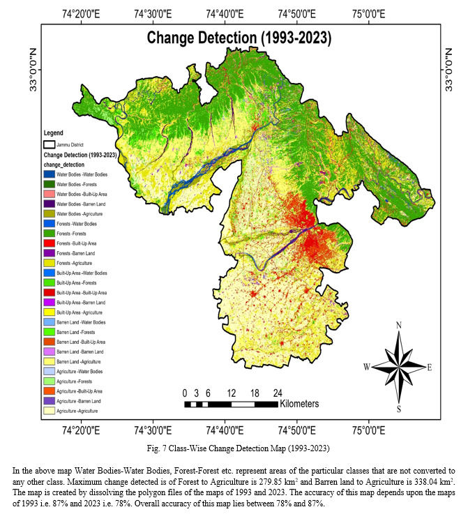
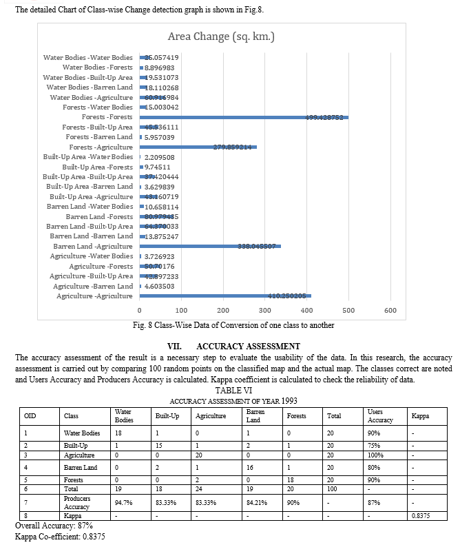
VIII. ANALYSIS AND INTERPRETATION OF LAND USE AND LAND COVER DATA
A. Water Bodies
From 1993-2023, the area under water bodies has been reduced to half from 132.58 km2 to 56.68 km2.Water bodies have faced maximum encroachment with 60.91 km2 converted to agriculture, 18.11 km2 converted to Barren land, 19.53 km 2 converted to Built-Up Area and 8.89 km2 converted to forests.
Water bodies also saw an increase in other areas with 3.7 km2 of agriculture land converted to Water bodies, 10.65 km2 of barren land converted to water bodies and 15 km2 of forest converted to water bodies.
Thereby, reducing the Water Bodies by 76 km2.
This change is due to varied reasons like
- Urbanization and Infrastructure Development: Urban areas expanded by 113 km2 in past 30 years as per our study, this is done by reclaiming land for construction purposes. This led to the filling and conversion of water bodies into built-up areas or land for other purposes like roads, housing, industries, and commercial spaces.
- Agricultural Expansion: The population of Jammu district has doubled from 783705 to 1744152. In many cases, water bodies have been converted into agricultural land occurs to meet the growing demands of food production. As population increased and agricultural practices intensified, water bodies were drained or filled to create more arable land for crop cultivation.
- Deforestation and Land Degradation: Deforestation and land degradation in the catchment areas of water bodies could have lead to a reduction in their size and volume. When forests are cleared for agriculture, logging, or urban expansion, the natural water retention capacity diminishes, resulting in decreased water flow and reduced water body sizes.
- Climate Change: Climate change influences the availability of water in an area. Changes in rainfall patterns, increased temperatures, and altered hydrological cycles can impact the water balance and cause the shrinkage or drying up of water bodies.
- Dam Construction and Water Diversion: In past 30 years, multiple dams have been constructed on Chenab River taking the number to 7 functional dams. The construction of dams and diversion of water for irrigation or other purposes have a significant affect to the water bodies. These interventions can alter natural water flows, reduce water availability downstream, and potentially lead to the drying up of smaller water bodies.
B. Built-Up Area
Built-Up Area is doubled in last 30 years from 96.21 km2 to 209.8 km2. This is due to increase in population from 7837051 to 1744152.Also, Jammu being a capital city and a major educational hub in northern India, a significant amount of people migrate to Jammu to for their educational or livelihood needs. Thus, leading to a demand pushed infrastructure growth.
There are various reasons of this change are:
- Population Growth: The population of Jammu district has doubled in last 30 years from 7837051 to 1744152. This is one of the primary drivers of urban expansion and the increase in built-up areas. As the population increases, there is a greater demand for housing, infrastructure, and commercial spaces, leading to the conversion of land into built-up areas.
- Infrastructure Development: The development of infrastructure, including roads, highways, bridges, and utilities is increased substantially. As transportation networks and utility services expand to accommodate growing urban populations, more land is dedicated to infrastructure development.
- Housing Demand: Increased urban populations and changing lifestyle preferences lead to a higher demand for residential housing. This demand drives the construction of housing complexes, apartment buildings, and residential areas, contributing to the expansion of built-up areas.
- Government Policies and Land Use Changes: The government has frequently changes policies, land use planning, and zoning regulations can influence the conversion of land into built-up areas. If land use policies prioritize urban development or relax restrictions on land conversion, it can facilitate the expansion of built-up areas.
- Informal Settlements and Slums: Many informal settlements and slums have grown on the outskirts of Jammu city. Such areas are occupied by refugees. These settlements have typically emerged on undeveloped or vacant land, leading to the expansion of urban areas.
C. Agriculture
Area under agriculture 29% in past three decades from 512.37 km2 in 1993 to 1132 km2 in 2023. Various factors analysed for this change are:
- Population Growth and Food Demand: As stated earlier, population of Jammu district has doubled in last 30 years from 7837051 to 1744152. It led to an increased demand for food, which drives the expansion of agricultural land. As the population increases, more land is required for crop cultivation to meet the rising food requirements of the growing population.
- Technological Advances and Intensification: The adoption of new technologies and agricultural practices, such as improved irrigation systems, mechanization, use of fertilizers, and high-yielding crop varieties, have enhanced agricultural productivity. These advancements have enabled farmers to cultivate larger areas of land, leading to an increase in the overall agricultural land.
- Government Policies and Support: As majority of our population depends on agriculture, both Govt. of J&K and Govt. of India have adopted policies such as MSP, easy credits, free fertilisers etc. to offer incentives to farmers can encourage the expansion of agricultural activities.
D. Barren Land
Barren Land has significantly decreased by 22% from 508.09 km2 to 46.19 km2. The probable factors are given:
- Agricultural Expansion: 338 km2 of barren land has been converted to agriculture to meet the increasing demand for food due to population growth and changing dietary preferences. As farmers expand their cultivation areas, they may have reclaimed barren land through land clearing and soil improvement measures.
- Reforestation and Afforestation Efforts: Reforestation and afforestation initiatives by planting trees or restoring vegetation cover on barren or degraded land. These efforts are done by government to increase forest cover, improve land productivity, enhance ecosystem services, and combat soil erosion. Reforestation and afforestation programs have converted 80 km2 into forest by restoring vegetation cover.
- Infrastructure Development and Urbanization: The expansion of infrastructure and urban areas led to the conversion of barren land into built-up areas. 64 km2 of such land is claimed for development projects such as roads, residential complexes, commercial spaces, and industrial sites, resulting in the reduction of barren land.
- Natural Succession and Ecological Processes: Over time, barren land undergoes natural succession, where vegetation gradually colonizes the area. This process can occur due to natural seed dispersal, windblown seeds, or the presence of persistent seed banks in the soil. Natural succession can contribute to the reduction of barren land as it transitions into more vegetated areas.
E. Forests
Area under forest cover has decreased by 9% from 846.31 km2 in 1993 to 650.17 km2 in 2023.
Various reasons researched for this area:
- Agricultural Expansion: With expansion in agricultural areas, forested areas may have been cleared to make way for agriculture, including commercial crops, subsistence farming, and shifting cultivation. 279 km2 of such land has been converted to agriculture.
- Logging and Timber Extraction: Unsustainable logging practices, illegal logging, and timber extraction for commercial purposes has also led to forest degradation and deforestation. The removal of trees for timber, furniture, and other wood products contributes to the loss of forest cover. 5 km2 of forest has been converted to barren.
- Infrastructure Development: The infrastructure development in the region, including roads, highways, dams, and mining operations, has led to clearing forested areas. Construction activities associated with infrastructure development result in the conversion of forests into built-up areas, contributing to the reduction in forest cover.
IX. FUTURE SCOPE OF WORK
This research can be extended to increased number of land classes such as Shrubs, Grasslands, Horticulture Areas, Industrial Areas, Mining, Snow etc. Annual growth in horticulture area in Kashmir and parts of Jammu can be mapped and studied and expansion of coal mines in Jammu can also be tracked. More advanced studies can help in detecting the health of crops and horticulture areas, thereby helping in estimating the production for the season. This research can also be extended to assess the damage due to floods, forest fires etc. as they lead to temporary change in land use. With the use of Machine Learning and Artificial Intelligence Software the future land use trends can be predicted analysing the past land use data.
X. ACKNOWLEDGMENT
The authors would like to thank Dr. Sanjeev Kumar Gupta, Head of the Department of Civil Engineering at Government College of Engineering and Technology, Jammu for his constant encouragement and support in this research. We would also like to thank Er. Mukesh Jamwal, Assistant Professor GCET Jammu for his guidance and mentorship which has been instrumental in shaping our research and academic endeavours.
Conclusion
The study successfully classified the Land use Land cover of Jammu district into 5 classes with 87% and 78% accuracy. Jammu district over the past 30 years reveals significant transformations in the region. 5% decrease in area under water bodies and 9% decrease of area under forest cover is a significant and concerning change. These findings show the complex inter-connection between human activities, economic development, and environmental changes in shaping land use patterns in Jammu district. Sustainable land management practices, conservation efforts, and the implementation of policies that balance economic development with environmental preservation are crucial for mitigating the negative impacts of land use changes and promoting sustainable land use practices in the region.
References
[1] Malik MI, Bhat MS. Anthropogenic Land Use Change Detection in a Kashmir Himalayan Watershed–A Remote Sensing and GIS Approach. Global Environmental Change. 2014; 11: 14p. [2] Kamp U, Growley BJ, Khattak GA, et al. GIS Based Landslide Susceptibility Mapping for the 2005 Kashmir Earthquake Region. Geomorphology. 2008; 101(4): 631–642p [3] Tali JA, Divya S, Murthy K. Influence of Urbanization on the Land Use Change: A Case Study of Srinagar City. American Journal of Research Communication. 2013; 1(7): 271–283p. [4] Bhat MM, Shah AR. Agricultural Land Use and Cropping Pattern in Jammu and Kashmir. Research Journal of Agricultural Sciences (RJAS). 2011; 2(3): 710–712p. [5] Bhagawat R. Application of Remote Sensing and GIS, Land Use/Land Cover Change in Kathmandu Metropolitan City, Nepal. J Theor Appl Inf Technol. 2011;23(2): 80–86p. [6] Wani MH, Baba SH, Shahid Y. Land-use Dynamics in Jammu and Kashmir. Agricultural Economics Research Review (AERR). 2009; 22(6): 145–154p.
Copyright
Copyright © 2023 Prof. Dr. Sanjeev Kumar Gupta, Anoop Kumar, Shivwant Kumar, Aman Singh, Sandeep Singh. This is an open access article distributed under the Creative Commons Attribution License, which permits unrestricted use, distribution, and reproduction in any medium, provided the original work is properly cited.

Download Paper
Paper Id : IJRASET55129
Publish Date : 2023-08-01
ISSN : 2321-9653
Publisher Name : IJRASET
DOI Link : Click Here
 Submit Paper Online