

Ijraset Journal For Research in Applied Science and Engineering Technology
Flood Control Strategy Chandoli Reservoir Using Tunnel Construction Approach a Case Study of Warna River in Kolhapur
Authors: Asha Owandkar, Jayashree Jogi, Tejas Sangle, Vivekanand Bachche, Dr. A. W. Dhawale
DOI Link: https://doi.org/10.22214/ijraset.2022.42116
Certificate: View Certificate
Abstract
Floods are the most frequent and damaging of all types of natural disasters and annually affect the lives of millions all over the globe. Against this background, enhanced climate variability and climate change are expected to increase the frequency and intensity of floods. There are growing demands for deep tunnels to mitigate severe rural flooding by providing a large tunnelling capacity for excess storm runoff. This study aims to assess the flooding mitigation effect of a deep tunnel system proposed in the old downtown of Kolhapur, India. By providing a sufficient tunnel of a particular type of size, we can reduce the flood force on the downstream side for minimizing the negative impacts of floods, often making the difference between life and death
Introduction
I. INTRODUCTION
Rainfall extremes cause flooding. Increased surface run-off, and precipitation higher than the capacity of outgoing discharge cause the water level to rise, leading to submergence of regions, debris flows/landslides, water-borne health disasters, and posing threats to sustainable development. Floods impact the ecosystem and society by destroying habitats, affecting lives, damaging infrastructure, etc. Nearly 40 m ha area in India is flood-prone and every year nearly 8 m ha of land is affected by floods. Apart from these, floods during the Rabi and Kharif seasons affect the food security of the nation. Due to the warming climate, increased frequency of rainfall extremes is reported in India. In addition, in recent decades, the warming trend over the Indian Ocean has potentially enhanced moisture supply leading to rainfall extremes in the country. Modern underwater tunnelling begins by constructing an immersed tube within a pre-dug trench on the river or seafloor, to do this pre-fabricated sections of steel and concrete tube are floated into position and strategically sunk into the trench
A. Limitations of Existing System
- Direct contact with water necessitates a careful waterproofing design around the joints.
- The segmental approach requires careful design of the connections, where longitudinal effects and forces must be transferred across.
- Environmental impact of the tube and underwater embankment on the existing channel.
II. OBJECTIVES
Based on the literature review and survey conducted in the study area, the following objective is set
- To suggest the plan of flood management system for preventing the loss of life and property from flooding.
III. LITERATURE REVIEW
A. Amir mosavi, published on, 28 October 2018
Floods are among the most destructive natural disasters, which are highly complex to model. The research on the advancement of flood prediction models contributed to risk reduction, policy suggestions, minimization of the loss of human life, and reduction of the property damage associated with floods. To mimic the complex mathematical expressions of physical processes of floods, machine learning (ML) methods contributed highly to the advancement of prediction systems providing better performance and cost-effective solutions during the past two decades. Due to the vast benefits and potential of ML, its popularity dramatically increased among hydrologists.
B. Galateia Terti,1, Isabelle Ruin, Jonathan J. Gourley.
This article focuses on conceptual and methodological developments allowing the integration of physical and social dynamics leading to model forecasts of circumstance-specific human losses during a flash flood. To reach this objective, a random forest classifier is applied to assess the likelihood of fatality occurrence for a given circumstance as a function of representative indicators. Here, the vehicle-related circumstance is chosen as the literature indicates that most fatalities from flash flooding fall in this category. A database of flash flood events, with and without human losses from 2001 to 2011 in the United States, is supplemented with other variables describing the storm event, the spatial distribution of the sensitive characteristics of the exposed population, and the built environment in the county level.
C. J. Teng, A.J. Jakeman b, B.F.W. Croke (Article · April 2017)
at: https://www.researchgate.net/publication/316512624 This paper reviews state-of-the-art empirical, hydrodynamic and simple conceptual models for determining flood inundation. It explores their advantages and limitations, highlights the most recent advances, and discusses future directions. It addresses how uncertainty is analysed in this field with the various approaches and identifies opportunities for handling it better. The aim is to inform scientists new to the field and help emergency response agencies, water resources managers, insurance companies and other decision-makers keep up to date with the latest developments. Guidance is provided for selecting the most suitable method/model for solving practical flood-related problems.
D. Saksena Rashmi (2007)
According to this report Bangladesh, a country very vulnerable to floods, saw flash flood and landslides in the Chittagong district take as many as 100lives and injure more than 60 people. Fish farms and rice fields were devastated and jute agriculture suffered. The capital city of Dhaka was in knee-high water during a recent flood. Due to an active monsoon rainfall 2007 water level in the majority of rivers are fast approaching the danger mark threatening to inundate more districts and areas.
E. Hire Pramod Kumar S. and Kale Vishwas S. (2006)
In this paper an attempt has been made to quantitatively evaluate the geomorphic effectiveness of three large magnitude floods occurred in 1959, 1968, and 1969 in the lower Tapi basin. Flood hydrographs of these and other flood events show that the duration of floods can range from 6 to 10 days, and in exceptional cases up to 15 days. Hence to produce substantial changes in the alluvial sections of the Tapi River.
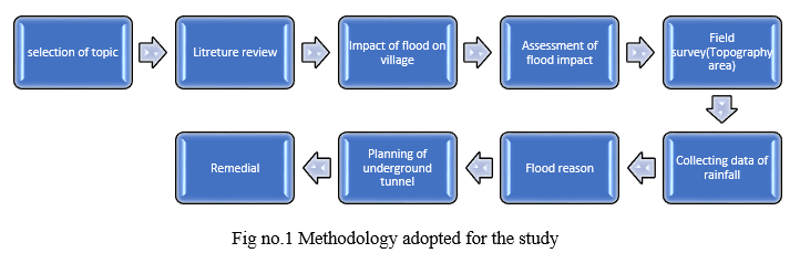
III. METHODOLOGY
For achieving the above set objective following methodology is adopted as shown in fig.1
A. Case study
Natural disasters are a leading cause of human mortality, cause damage to private and public property, deterioration of human health, and environmental degradation. Natural disaster impact and disaster intensity are similar across developed and developing countries, but developed countries have better disaster management and advanced disaster warning systems to prevent the post and pre-disaster impact compared to developing nations. Evidence shows that the USA has faced the highest number of disaster events (506 reported events between 1974-2003) compared to any other country, but less number of people have become victims of these disaster events (4.5 million between1974-20030
B. Field Survey
A field survey is conducted by collecting and gathering information at the local level by conducting primary surveys. The primary surveys are also called field survey.
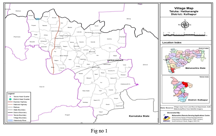
For the selection of village, firstly we visited several villages Also we visit their corresponding authorities for the collection of basic data likewise total area, an agricultural area, residential area, A village After that we collected the data on Flood impact & also observed that condition of that village after the flood. All-knowing the point of above mentioned Finally we selected the village which is more impacted due to flood as compared to others which village is June Pargaon.The area is shown in fig given below.
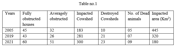
C. Assessment of Flood Impact on June Paregaon
D. Reason of Flood
Following are the reasons which cause flooding in the study area.
- Heavy Precipitation: Rainfall of about 15 cm or more in a single day may be beyond the carrying capacity of the river and this causes the spilling of the river over natural banks.
- Rise in River Bed: Due to large gradients, the Himalayan rivers carry a large amount of silt and sand which are ultimately deposited in the catchment area, and on the river bed. Siltation reduces the carrying capacity of the river.
- The Meandering Tendency of River flow: In the flat terrain rivers tend to meander or change their course within a specific boundary. Lower reaches of Gangetic plains and Brahmaputra.
- Cyclones: Tropical cyclones accompanied by strong winds, and high tidal bores cause inundation of coastal regions.
E. Planning of Underground Tunnel
This is the method we adopted to divert the floodwater.
- Material: Dig a trench in the riverbed or ocean floor. They then sink pre-made steel or concrete tubes in the trench. After the tubes are covered with a thick layer of rock, workers connect the sections of tubes and pump out any remaining water.
- Area: The location of the tunnel from Mandur to Manewadi approximate distance of tunnel will be 10 to 11 km Manewadi have a less rainfall area where the irrigation and drinking purpose are incomplete.
- Tunnel Site: From the downstream side of the dam from a distance of 1km. the first tunnel will be placed and after every 500 meters, the other three tunnels will be provided for diversion of the water to the East side.
- Dam Capacity: Chandoli dam have 34.4TMC. capacity and the high discharge rate of the dam is 4400cusec.
- Size and Shape of the Tunnel: The tunnel has a circular shape so that we can easily divert the water with the slope on the west of the approximate diameter of 5.6m. The tunnel will be 5m underground from ground level.
- Control: We will control it by manual as well as an automatic system. the doors are provided at the opening of the tunnel
Conclusion
After doing the study of June Pargoan following conclusion is drawn 1) Provide an underground tunnel to minimize the loss of life and property from flooding. 2) Developed the plan to reduce the area of inundation on floodplains. 3) Recommendation of given study will help the local authorities for future planning.
References
[1] Arts, B. et al., 2006. “Political modernization and policy arrangements: a framework for understanding environmental policy change” Public organization review 6(2): 93-106 [2] Bakker, M. H. N., 2006. Transboundary River Floods: Vulnerability of Continents, International River Basins and Countries. PhD Dissertation, Oregon State University, Corvallis. [3] Bakker, Marloes H.N., 2009. Transboundary River Floods and Institutional Capacity. Journal of the American Water Resources Association (JAWRA) 45(3):553-566. Becker, G.,J.Aerts, and D. Huitema, 2007. Transboundary Flood [4] Gupta, J. et al., 2010. “The adaptive capacity wheel: a method to assess the inherent characteristics of institutions to enable the adaptive capacity of society” Environmental Science and Policy 13(6): 459-471 [5] Guha-Sapir et al., 2004. Thirty Years of Natural Disasters 1974– 2003: the Numbers. Centre for Research on the Epidemiology of Disasters, Louvain-la-Neuve, p. [6] Haque, C. E. (2003). Perspectives of natural disasters in the east and south Asia and the Pacific Island states: socio-economic correlates and needs assessment. Natural Hazards, 29, 465–483. [7] Holling, C. S. (2001). \"Understanding the complexity of economic, ecological, and social systems.\" Ecosystems 4(5): 390- 405 [8] Amir Mosavi (2018). Flood prediction using machine learning model’s review [9] Galateia Terti,1, Isabelle Ruin, Jonathan J. Gourley. Toward Probabilistic Prediction of Flash Flood Human Impacts
Copyright
Copyright © 2022 Asha Owandkar, Jayashree Jogi, Tejas Sangle, Vivekanand Bachche, Dr. A. W. Dhawale. This is an open access article distributed under the Creative Commons Attribution License, which permits unrestricted use, distribution, and reproduction in any medium, provided the original work is properly cited.

Download Paper
Paper Id : IJRASET42116
Publish Date : 2022-05-01
ISSN : 2321-9653
Publisher Name : IJRASET
DOI Link : Click Here
 Submit Paper Online