

Ijraset Journal For Research in Applied Science and Engineering Technology
Identification and Mitigation of Blackspots and Implementation of An Advanced Traffic Management System on NH-216A (A Spur of National Highway-16)
Authors: Maanyam Ramakrishna, Bandaru Ramesh
DOI Link: https://doi.org/10.22214/ijraset.2022.42177
Certificate: View Certificate
Abstract
As the population is increasing day by day the number of vehicles is also increasing. As the number of vehicles is increasing, the number of accidents also increases. Analysis of previous data indicates that 66% of the accidents occur due to human error and 33% due to road parameters such as road and vehicle interaction, other road users, and environmental factors. Road safety has recently become a major concern in most modern societies. The identification of sites (black spots) that are more dangerous from an accident point of view can help in better scheduling road safety policies. The study includes the collection of accident data and prioritizing the accident-prone locations by using the Weighted Severity Index (WSI) method. This study includes the identification of Accidental Black Spots and improving these Accidental Black Spots by using ATMS. This project emphasizes accident studies on the National Highway-216A (Diwancheruvu to Siddantham) in East Godavari District, State of Andhra Pradesh, India. So the main aim of this study is, therefore, to identify the major accident black spots on National Highway -16 and mitigation of Accidental Black Spots by using Advanced Traffic Management System.
Introduction
I. INTRODUCTION
A. Accidents
The increase in the number of motor vehicles is due to the growth of population and unconventional growth of technology and economics. As mobility increases, the probability of accidents also increases. The basic elements in traffic accidents are road users, vehicles, road and its condition, road geometry, and environmental factors, etc. The fatality rate is more in developing countries as compared to developed countries.
The main cause of road accidents is drunken driving, careless and rash driving, over speeding, sudden braking, skidding, traffic rule violation, sudden twists, and turns while driving, etc. Moreover, road accidents can affect 1% of the annual gross product resources of developing countries.
Road accidents cannot prevent/stop, but by using suitable traffic engineering, safety plan, and management measures, the accident rate can be decreased. One of the most important factors to reduce traffic is the identification of hazard locations. In recent years, road safety and the rapid growth of traffic have become a major concern throughout the world. A road traffic accident is a major problem.
As per the Road Accident Report for 2019, a total number of 4,49,002 accidents took place in the country during the calendar year 2019 leading to 1,51,113 deaths and 4,51,361 injuries. Road accidents in India kill almost 1.5 lakhs of people annually. Accordingly, India accounts for almost 11% of the accident-related deaths in the World. It is estimated that the economic losses due to road accidents in India are over Rs 100 billion per year. The identification of accident location, analysis, and treatment of road accident black spots are widely regarded as one of the most effective approaches to road accident prevention.
B. Road Accident
Road Accident is an accident (collision, overturning, or slipping) that occurred or originated on a road open to public traffic resulting in either injury or loss of life, or property damage, in which at least one moving vehicle is involved.
C. Accident Type
- Fatal: An accident in which one or more persons are killed.
- Major (Hospitalised): An accident in which none of the victims are killed however at least one person has sustained one or more serious injuries such as fractures, internal body injury, severe general shock, unconsciousness and needs hospitalization for medical treatment.
- Minor (Not Hospitalised): An accident in which none of the victims were killed nor was any victim hospitalized. However, at least one of the victims has a slight injury and requires first aid.
- No Injury: An accident in which were harmed in any way and does not even require first aid. However, public or private property may have been damaged and requires restoration.
D. Black Spot
A black spot is a place on a road that is considered to be dangerous because several accidents have happened there. Accidents happened there because of a variety of reasons, such as sharp curves in a straight road, so oncoming traffic is concealed, the design of junctions is not proper on a fast road, poor or concealed warning signs at a crossroads. Accident black spots can be improved by improving the signage, speed restrictions, improving sightlines, straightening bends, etc. In Andhra Pradesh, in the last ten years, 33,922 accidents occur in which 10,727 people died and approximately 54,702 people were injured. It shows that every year in Andhra Pradesh more than 1000 people died in road accidents. The major causes of road accidents in Andhra Pradesh are the condition of roads are not good and also the rough driving is responsible for this.
1. Definition of Road Accident Black Spot as per MoRT&H: Road Accident Black spot is a stretch of National Highway of about 500m in Length in which either 5 road accidents (in all three years put together involving fatalities/grievous injuries) took place during the last 3 calendar years or 10 fatalities (in all three years put together) took place during the last 3 calendar years.
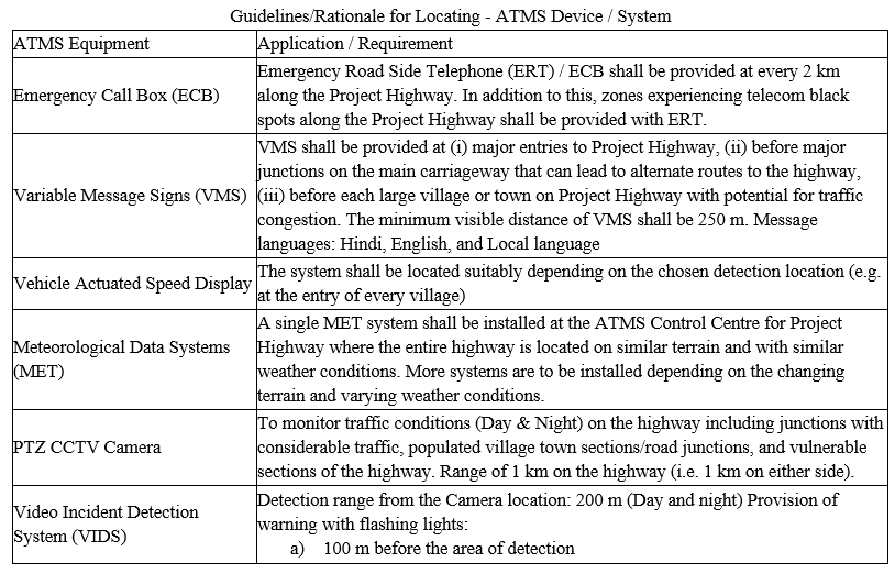
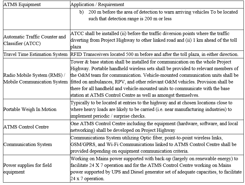
2. Advanced Traffic Management System (ATMS): A system of vehicle detectors, cameras, and communication systems is used to monitor traffic, optimize signal timing, and improve the flow of traffic. The difficulties arising in controlling traffic congestion have attracted the attention of many researchers to work in the areas of Advanced Traffic Management System (ATMS). Intersections integrated with intelligent technologies have the potential to control traffic congestion and its outcomes. Advanced Traffic Management System (ATMS) is an efficient and cost-effective solution to manage highway traffic by collecting real-time information, processing, analysing, and finally providing the proper solution according to the situation to the users. Various applications of the Advanced Traffic Management System (ATMS) are suggested which will help to manage the traffic efficiently, reduce the traffic congestion on the study route and improve the road safety of the road users. The study provides possible solutions for reducing traffic congestion through the application of the Advanced Traffic Management System (ATMS). Broadly, the ATMS implementation shall cover the design, supply, installation, commissioning, and operation and maintenance of Advanced Traffic Management Systems (which is one of the components of Intelligent Transport System – ITS). The system would include outdoor equipment including emergency call boxes, variable message sign systems, vehicle actuated speed system, meteorological data system, close circuit TV camera (CCTV) system, traffic counting and classification system, mobile radio communication system, and transmission system. The indoor equipment would comprise a large display board, central computer (with Network Management System – NMS), CCTV monitor system, call center system, or management of emergency call boxes housed in a control center with uninterrupted power supply.
The systems shall meet the following objectives:
a. Smooth and uninterrupted traffic flow
b. Enhance road safety
c. Real-time information and guidance to users
d. Emergency assistance round the clock
e. Alerts for abnormal road and weather conditions
f. Reduced journey time and inconvenience
II. METHODOLOGY
The methodology of the project is shown in the flowchart given below.
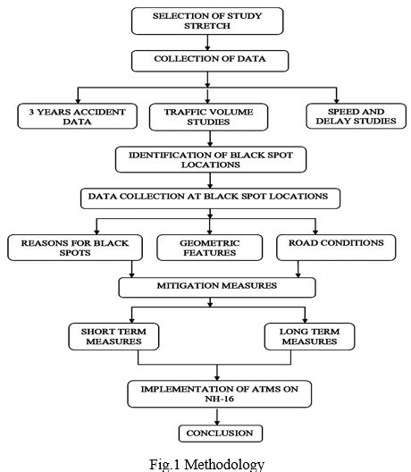
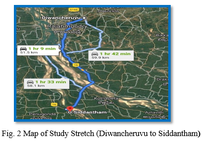
A. Selection of Study Stretch
The area which is selected for accident studies is 49 km long National Highway-216A (a spur road of National Highway-16) section between Diwancheruvu to Siddantham from Km. 901+500 to Km. 950+542, Andhra Pradesh.
National Highway 216A is a spur road of National Highway-16 which is a major National Highway in India, that runs along the east coast of West Bengal, Odisha, Andhra Pradesh, and Tamil Nadu. It was previously known as National Highway 5.
Many cities and towns in various districts in the States of West Bengal, Odisha, Andhra Pradesh, and Tamil Nadu are connected by National Highway 16. NH 16 has a total length of 1,764 km (1,096 mi) and passes through the states of West Bengal, Odisha, Andhra Pradesh, and Tamil Nadu.
B. Collection of Data
The data collected are 1
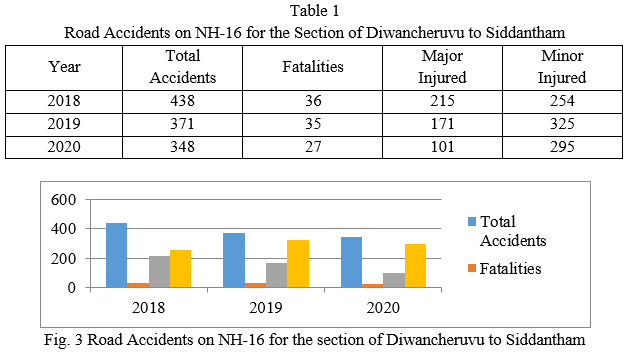
1. Accident Data Collection: The past 3 years (2018 To 2020) accident data is collected from the National Highways Authority of India for the section of Diwancheruvu to Siddantham section (from Km. 901+500 to Km. 950+542). The analysed accident data is represented in table
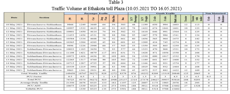
2. Traffic Volume Studies: The Traffic volume studies are carried out manually for one week by taking vehicle data for the section of Diwancheruvu to Siddantham at Ethakota Toll Plaza. Daily vehicle details are noted in the datasheet shown in table 2. The data is collected for different vehicles based on axle loads and are grouped for PCU.
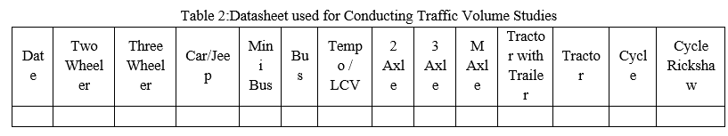
The traffic volume studies are conducted at Ethakota Toll Plaza on both sides of the carriageway from 10.05.2021 to 16.05.2021 timing 24X7. The vehicle data is collected and presented in table 3.
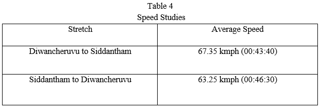
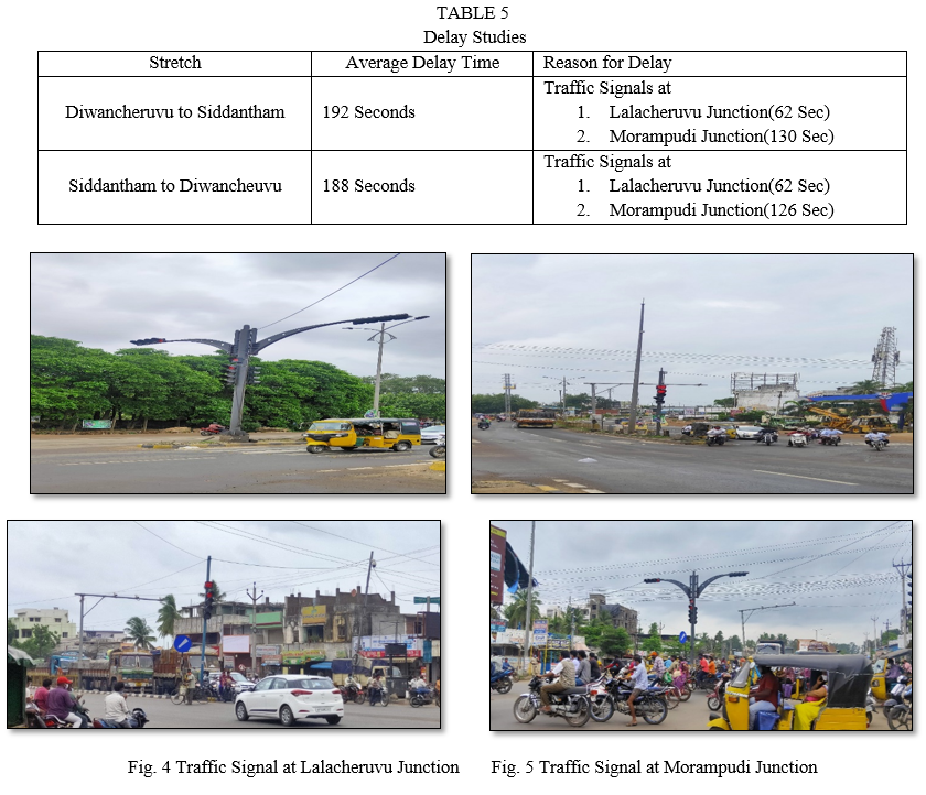
3. Speed and Delay Study: The speed and delay study was carried out by using the moving observer method from Diwancheruvu to Siddantham (49.042 Kms) and Siddantham to Diwancheruvu (49.042 Kms) to find out the average journey speed presented in table 3.4 and delay of the traffic stream is presented in table 3.5.
a. Speed Studies
b. Delay Studies
C. Identification of Black Spots
The accident data of the Diwancheruvu to Siddantham section for the duration of 2018 to 2020 is collected from the National Highways Authority of India and the data is analysed as per the MoR&H circular RW/NH-15017/109'2015-P&M(RSCE), dated 28.10.2015. as per the MoRT&H circular Road, Accident Black Spot is a stretch of National Highway of about 500m in Length in which either 5 road accidents (in all three years put together involving fatalities/grievous injuries) took place during the last 3 calendar years or 10 fatalities (in all three years put together) took place during the last 3 calendar years. The data is analysed and the Black Spot locations are presented in table 6.
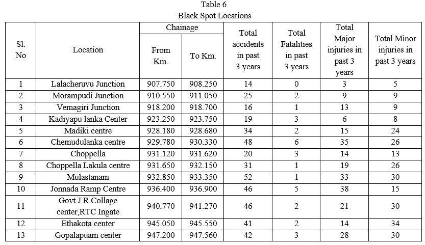
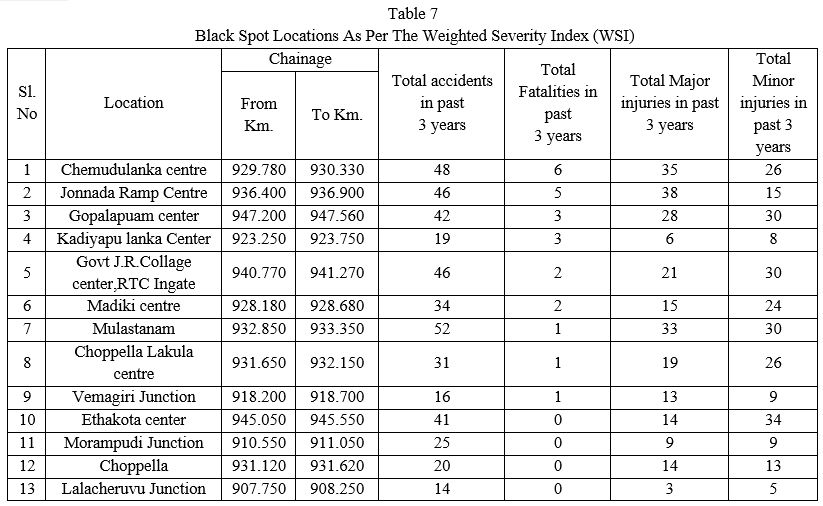
- Weighted Severity Index (WSI): In this method, the weighted severity index is calculated based on the classification of accidents as fatal, grievous injuries and minor injuries. Location having the highest severity index value is ranked first followed by the rest. The concept of this method is that the fatality or injury crashes are given greater weightage than property damage-only crashes. The data is analysed and the Black Spot locations as per the Weighted Severity Index (WSI) are presented in table 7.
III. DATA COLLECTION AT BLACK SPOT LOCATION
The data collection at the black spot located in the present study is detailed in the below figure.
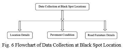
- The data collection involves Location details Road Features, Median opening details, Approach Road conditions, Intersection details, and Pavement cross-sections.
- Pavement condition involves Alligator cracking, Bleeding, Block cracking, Bumps and sags, Corrugations, Depressions, Edge cracking, Joint reflections, Lane/shoulder drop-off, Longitudinal, and transverse cracking, Potholes, Rutting, Shoving, Slippage cracking, Swelling, Ravelling.
- Road Furniture condition involves the condition of Road Markings, Road Signs, Road Studs, Safety Barriers, Guard Posts, Traffic Delineators, and Highway Lighting.
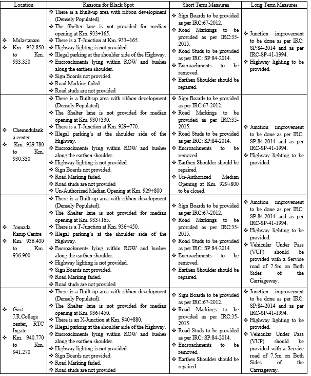
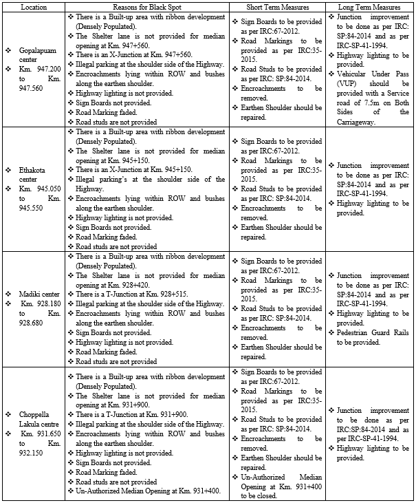
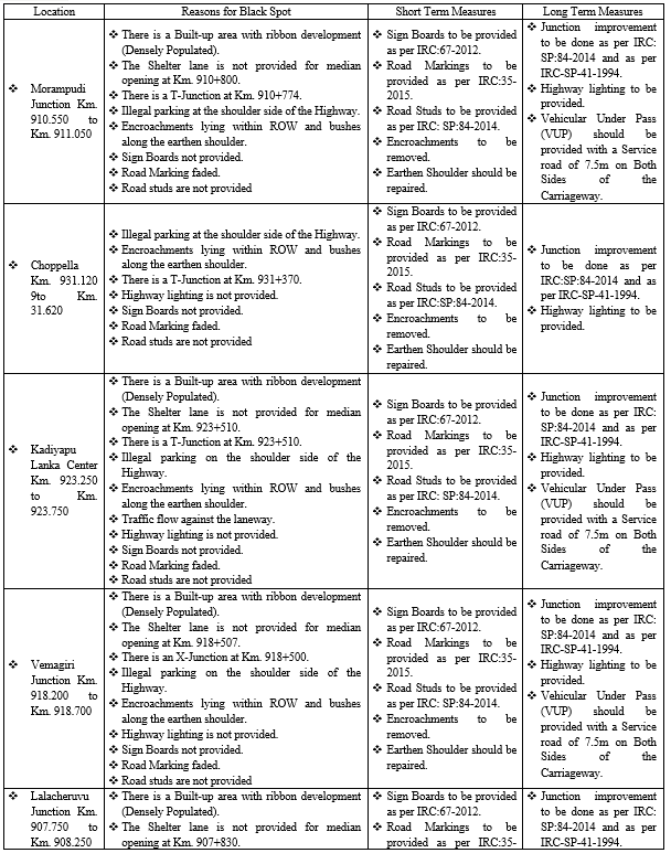
IV. REASONS AND MITIGATION MEASURES AT BLACK SPOT LOCATIONS
V. IMPLEMENTATION OF ADVANCED TRAFFIC MANAGEMENT SYSTEMS
Applications of the Advanced Traffic Management System (ATMS) are suggested which will help to manage the traffic efficiently, reduce the traffic congestion on the study route and improve the road safety of the road users. The study provides possible solutions for reducing traffic congestion by the application of the Advanced Traffic Management System (ATMS).
A typical ATMS implementation shall comprise of at least the systems/sub-systems depicted as below:
- Video Surveillance System (CCTV)
- Video Incident Detection System(VIDS)
- Vehicle Actuated Speed Display
- Emergency Road Side Telephone System
- Variable Message Signs (VMS) [Fixed and Portable]
- Meteorological Data System (MET)
- Weigh-in-Motion system
- Automatic Traffic Counter cum Classifier (ATCC)
- Network / Communication Infrastructure system
- Mobile Radio Communication System
- Travel time Estimation system
- ATMS Control Centre
VI. ACKNOWLEDGEMENT
I would like to express my gratitude to the management and Principal sir Professor. P V Surya Prakash M-Tech (PhD), Pydah College of Engineering, for their encouragement.
I would also like to thank the Head of the Department B. Ramesh M-Tech, for his support and encouragement for doing this work.
Conclusion
A. The identification and analysis of accident black spots help in identifying the stretches where accidents are more and these spots reduce road safety in general. B. The spot-on road where traffic accidents frequently occur is termed as black spots. The current study was an attempt to find out the most vulnerable accident locations or black spots on NH-16 in East Godavari District, Andhra Pradesh. The Weighted Severity Index (WSI) method was used to rank the accident locations. We have suggested some possible alternative measures to improve the safety and effective transportation system. C. The safety hazards are observed along project highways such as Un-Authorized Median openings, deficiencies in illumination (Highway lighting), and Road furniture items. It is suggested that priority be given to improving the safety at Median opening and Junction locations. The suggested priority action plan is to improve the road markings, develop the Junctions, improve the visibility of signage and maintain them in good condition. D. The implementation of the Advanced Traffic Management system is started on NH-16 from Anakapalli to Gundugolanu. We are meeting the officials of the NHAI and the Concessionaire of the study stretch in that meeting they said that the implementation will be completed by the end of 2021 and the Advanced Traffic Management System is available from 2022 in the project stretch.
References
[1] Snehal U. Bobade, Jalindar R. Patil, R. R. Sorate, “Identification of Accidental Black Spots on National Highways and Expressways”, International Journal Of Research in Advent Technology, 2015. [2] R.R. Sorate, R.P. Kulkarni, S.U. Bobade, M.S. Patil, A.M. Talathi, I.Y. Sayyad, S.V. Apte, “ Identification of Accidental Black Spots on National Highway 4 ( New Katraj Tunnel to Chandani Chowk ).”, IOSR Journal Of Mechanical and Civil Engineering, Vol. 12, PP61-67, 2015. [3] Aruna D. Thube, Dattatraya T. Thube, “Accident Black Spots on Rural Highways in India: A Case Study”, International Journal of Civil Engineering and Technology., Volume 1, Number 1,2010. [4] Naidu. V .M., Venkat L and P. I. Vamsi, “ Identification and Analysis of Black Spots on NH5- Visakhapatnam.”, Global Journal Engineering and Applied Sciences-ISSN 2249-2623, Vol 3,2011 [5] Traffic Engineering And Transport Planning, L.R.Kadiyali, Khanna Publications [6] Ministry of Road Transportation and Highway (MoRT&H) circulars [7] Black Spots Analysis Manual of Road Accidents: MoRT&H circular RW/NH-15017/109\\\'2015-P&M(RSCE), dated 28.10.2015 [8] Jitul Kumar Laphong, “Advanced Road Traffic Management System” IJISRT Volume/Issue : Volume 4 - 2019, Issue 3 - March [9] Bhagat N.K ,“Traffic Management using Intelligence in Transportation Systems” January 2016,DOI:10.13140/RG.2.2.16152.60168 [10] Advanced Traffic Management System Policy Matter-Technical (214/2016), dated 15.09.2016 [11] IRC: SP:84-2014 Manual of specifications & standards of 4 laning of highways [12] IRC-SP-88-Manual on Road Safety Audit [13] IRC-SP-41-1994 - Guidelines For Design of At-Grade Intersections
Copyright
Copyright © 2022 Maanyam Ramakrishna, Bandaru Ramesh. This is an open access article distributed under the Creative Commons Attribution License, which permits unrestricted use, distribution, and reproduction in any medium, provided the original work is properly cited.

Download Paper
Paper Id : IJRASET42177
Publish Date : 2022-05-03
ISSN : 2321-9653
Publisher Name : IJRASET
DOI Link : Click Here
 Submit Paper Online