

Ijraset Journal For Research in Applied Science and Engineering Technology
IoT based Landslide Detection and Monitoring System
Authors: Mrunal Jawalkar, Nikita Malviya, Prerna Hage, Shraddha Chakule, Pranav Pattewar
DOI Link: https://doi.org/10.22214/ijraset.2022.43135
Certificate: View Certificate
Abstract
According to recent survey 64.15% of fatalities are due to natural calamities which includes landslide as the major problem. Studies show that due time consuming and unreliable prediction system there is increase in rate of fatalities due to landslide. Only way to reduce these severe effects is predicting landslide efficiently and accurately without consuming much time. Most of the papers surveyed use sensor technology, and the most commonly used one is WSN (Wireless Sensor Network) since this sensor network provides large scale monitoring. If the chance of occurrence of landslide is high after the prediction an alert is sent to the disaster management department. Each of these methods have different percentage of accuracy. This survey paper discusses various approaches for detecting and predicting landslide thereby reducing fatalities.
Introduction
I. INTRODUCTION
A landslide is movement of a mass of rock, debris, or earth down a slope. In monsoons the rain water percolates and develops hydraulic pressure which exceeds the elastic limit of the soil or rocks. Due to this the strain gets accumulated which forces the soil and rocks to loosen their adhesive strengths entailing landslides. Landslides destroy agricultural/forest lands, road transports, destroys earth’s natural environment as a whole causing great loss to life. Landslides can also be said of “Mass Wasting”, which refers to any down slope movement of soil and rock due to gravity. It causes property damage, injury and death. Also, it adversely affects a variety of resources such as water supplies, fisheries, sewage disposal systems, dams and roadways for years after a slide event. The landslides occur when the slope changes from a stable to an unstable condition. This change in the stability of a slope can be caused by many factors together or alone. The Natural causes, such as, ground water pressure acting to destabilize the slope, erosion at the bottom of a slope by rivers or ocean waves, earthquakes adding loads to barely stable slope, earthquake caused liquefaction destabilizing slopes. The Manmade causes, such as, deforestation, cultivation and construction which destabilizes the already fragile slopes, vibrations from machinery or traffic. Rock avalanches, debris flows, soil movement, mud flows are the various forms of landslide. Landslides occur in rocky mountainous regions like Himalayas, konkan railways, lonavala ghats and marshy regions of kerala in India. Lanslides are hazards all over the world. Hillsides with steep slopes are prone to landslides. Landslide prediction, detection and monitoring have been done by researchers for different case studies all over the world. Landslide detection can be done by using diverse methods like visual inspection using image/video processing, satellite remote sensing, using statistical methods or using machine learning algorithms. Landslide detection can also be based on data driven approaches using wireless sensor networks (WSN). The main objective to study the landslide detection is to prevent the natural calamity by detecting its early movement. This will reduce or save the human loss caused by the landslide. Also, the objective is to find a certain way in which the sensing elements should respond quickly to rapid changes of data and send this sensed data to data analysis center. The proposed WSN/Internet of things (IoT) based landslide detection and monitoring system is a low cost, robust and delay efficient.
II. LITERATURE REVIEW
Landslide detection is also done based on image processing, video processing and machine learning algorithms. One such image processing work is discussed for the landslides occurring in Konkan region of India, where due to landslide the railway tracks shift and there is a loss. So, in order to prevent it an effective and efficient landslide detection system is designed [6] where the system monitors using image processing with a low-resolution webcam which acquires sample video frames. MATLAB is used for coding and with various techniques such as Hamming distance, Entropy, Euclidean distance, Correlation, Block processing, etc. were used for detection. This technique gives a certain threshold margin of about 80.24% and average efficiency of system was found to be 86.67% for considered set of images.
FAR: False Acceptance Ratio and FRR: False Rejection Ratio techniques are used. FAR and FRR are computed for different threshold values for a set of images and after computing and comparing for threshold 8 very low FAR (0.067) and FRR (0.933) can be achieved [10] . The work proposed in this paper is a WSN-IoT based, comparatively low cost and delay efficient landslide detection and monitoring system.
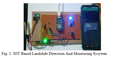
III. COMPONENT OF IOT BASED LANDSLIDE DETECTION AND MONITORING SYSYTEM
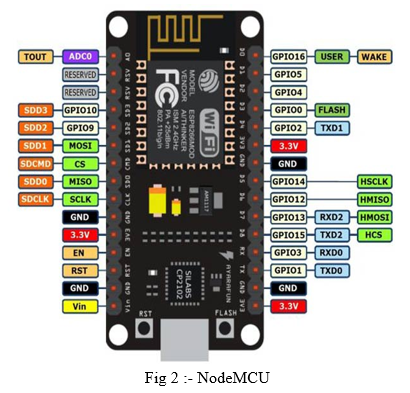
A. NodeMCU
- Microcontroller: Tensilica 32-bit RISC CPU Xtensa LX106
- Operating Voltage: 3.3V
- Input Voltage: 7-12V
- Digital I/O Pins (DIO): 16
- Analog Input Pins (ADC): 1 5) UARTs: 1
- SPIs: 1
- I2Cs: 1
- Flash Memory: 4 MB
- SRAM: 64 KB
- Clock Speed: 80 MHz
- USB-TTL based on CP2102 is included onboard, Enabling Plug n Play
- PCB Antenna
- Small Sized module to fit smartly inside your IoT projects
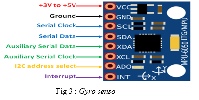
B. Gyro sensor
The MPU6050 module is a Micro Electro-Mechanical Systems (MEMS) which consists of a 3-axis Accelerometer and 3-axis Gyroscope inside it. This helps us to measure acceleration, velocity, orientation, displacement and many other motion related parameter of a system or object.
- Microcontroller: Tensilica 32-bit RISC CPU Xtensa LX106
- Operating Voltage: 3.3V
- Input Voltage: 7-12V
- Digital I/O Pins (DIO): 16
- Analog Input Pins (ADC): 1
- UARTs: 1
- SPIs: 1
- I2Cs: 1
- Flash Memory: 4 MB
- SRAM: 64 KB
- Clock Speed: 80 MHz
- USB-TTL based on CP2102 is included onboard, Enabling Plug n Play
- PCB Antenna
- Small Sized module to fit smartly inside your IoT projects
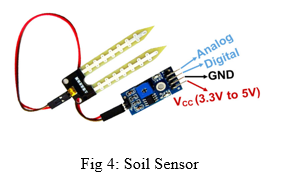
C. Soil Sensor
This soil moisture sensor module is used to detect the moisture of the soil. It measures the volumetric content of water inside the soil and gives us the moisture level as output. The module has both digital and analog outputs and a potentiometer to adjust the threshold level.
- Operating Voltage: 3.3V to 5V DC
- Operating Current: 15mA
- Output Digital - 0V to 5V, Adjustable trigger level from preset
- Output Analog - 0V to 5V based on infrared radiation from fire flame falling on the sensor
- LEDs indicating output and power
- PCB Size: 3.2cm x 1.4cm
- LM393 based design
- Easy to use with Microcontrollers or even with normal Digital/Analog IC
- Small, cheap and easily available
IV. COMPONENTS AND SOFTWARE USED IN IOT BASEDV LANDSLIDE DETECTION AND MONITORING
Components and software used in IOT Based Landslide Detection System are as follows:
A. Components
- NodeMCU
- GyroSensor
- Soil Sensor
- Resistors
- IC
- Power Supply
- Connecting Cables
B. Software
- AurdinoIDE
- BLYNK Application
- Diptrac
V. ADVANTAGES OF IOT BASEDV LANDSLIDE DETECTION AND MONITORING
- IOT Based technology as the capacity of large scale deployment and real time detecting of landslide losses.
- IOT based network detect the slightest movements of a ground or slop instability due to the several reasons such as dielectric moisture, pore pressure and so on that may occurs during a landslide.
- It has the ability of automatic tools to acquire and elaborate data independently.
- Easy to operate.
- To save the human life and sources.
- The main objective to study the landslide detection is to prevent the natural calamity by detecting its early movement.
- The purpose internet of thing based landslide detection and monitoring system is low cost robust and delay efficient.
Conclusion
Real time monitoring of landslides is one of the challenging research areas available nowadays within the field of geophysical research. The event of an actual field deployment of a wireless device network primarily based landslide detection system. This system uses wireless sensor nodes, MQTT protocol for efficient delivery of real time data to the system for monitoring and provide warning and risk assessments to the inhabitants of the area. This network will be used for understanding the capability and usability of wireless sensor network for critical and emergency application
References
[1] Romdhane, Rihab Fekih, Y. Lami, D. Genon-Catalot, N. Fourty, A. Lagrèze, D. Jongmans, and L. Baillet. \"Wireless sensors network for landslides prevention.\" In 2017 IEEE International Conference on Computational Intelligence and Virtual Environments for Measurement Systems and Applications (CIVEMSA), pp. 222-227. IEEE, 2017 [2] Wang, Honghui, Xianguo Tuo, Dashun Xi, Leilei Fan, Zhaoyi Zhang, Guiyu Zhang, and Shuli Hao. \"Research on one zicm2410-based wireless sensor network for landslide monitoring.\" In 2011 7th International Conference on Wireless Communications, Networking and Mobile Computing, pp. 1-4. IEEE, 2011. [3] Giorgetti Andrea, Matteo Lucchi, Emanuele Tavelli, Marco Barla, Giovanni Gigli, Nicola Casagli, Marco Chiani, and Davide Dardari. \"A robust3 wireless sensor network for landslide risk analysis: system design, deployment, and field testing.\" IEEE Sensors Journal 16, no.16 (2016): 6374-6386. [4] Lee, H.C., Ke, K.H., Fang, Y.M., Lee, B.J. and Chan, T.C., 2017. Open-source wireless sensor system for long-term monitoring of slope movement. IEEE Transactions on Instrumentation and Measurement, 66(4), pp.767-776. [5] Wu, Jianchao, Qingzhao Kong, Weijie Li, and Gangbing Song. \"Interlayer slide detection using piezoceramic smart aggregates based on
Copyright
Copyright © 2022 Mrunal Jawalkar, Nikita Malviya, Prerna Hage, Shraddha Chakule, Pranav Pattewar. This is an open access article distributed under the Creative Commons Attribution License, which permits unrestricted use, distribution, and reproduction in any medium, provided the original work is properly cited.

Download Paper
Paper Id : IJRASET43135
Publish Date : 2022-05-23
ISSN : 2321-9653
Publisher Name : IJRASET
DOI Link : Click Here
 Submit Paper Online