

Ijraset Journal For Research in Applied Science and Engineering Technology
Morphometric Analysis in Varuna River Basin: A Geoinformatics Based Analysis
Authors: Anshika Varshney, Dr. Sudhakar Shukla
DOI Link: https://doi.org/10.22214/ijraset.2022.40642
Certificate: View Certificate
Abstract
Varuna River is an important tributary of river Ganga. For the present study River Varuna has been chosen for the morphometric analysis and the demarcation of the basinal area of the river has been automatically done through Geospatial tool known as Arc Hydro. The study regarding the morphometry of the river lets us infer about the basin geometry, network system of the drainage and more of the river basin characteristics. Calculations of the morphometry will give us the quantitative description of the drainage system, which is an important aspect of the basins. This will describe the shape, slope, elongation, drainage density and many more important values to further incorporate water management processes in the varuna river basin. GIS tools will help us achieving morphometric analysis. With the help of morphometric analysis we are able to gain knowledge regarding the basin geomorphology and its responses to various hydrological processes.
Introduction
I. INTRODUCTION
The Varuna river basin is a part of Indo Gangetic basin. Varuna river and its sub-watersheds are the ones which controls the drainage system of Varanasi city and also they control the flow of the groundwater over the adjoining area. Due to fast paced urbanization and immense pumping and usage, groundwater is depleting rapidly over parts of the basin. Discharge of pollutants into the different environmental components makes it difficult to control them from evacuating out of the system. Further, contamination of the rivers by domestic and industrial liquid waste has led to the deterioration of river health. The over exploitation of river resource takes us to the harsh reality of facing scarcity of water in coming future.
II. STUDY AREA
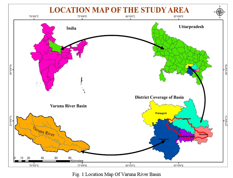
The Varuna River is a minor tributary of Ganges River in Uttar Pradesh, India. It originates at 25°27′N, 82°18′E, at a place called Malahan near Phulpur in the Prayagraj district and merges into the Ganges at 25°19′46″N, 83°02′40″E near Sarai Mohana in the Varanasi district (Fig. 1).
The 6 kilometres stretch between Sarai Mohana and Sadar, Varanasi, Uttar Pradesh is prone to flooding. The name Varanasi is originated from the name of two rivers, Varuna and Assi. The climate of the region is tropical monsoonal. Varuna River covers an area of about 3622 km2 of the Ganga Plain. Varuna Plain is drained by Alluvial Soil.
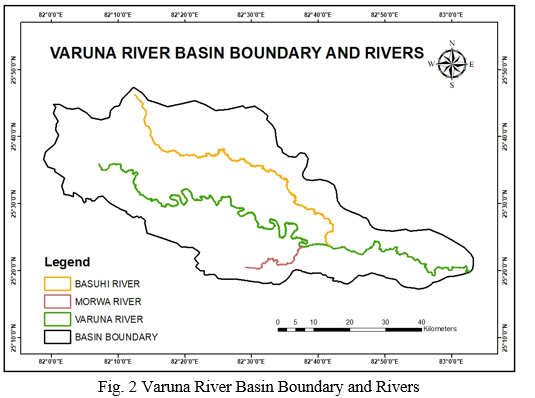
Varuna river (Fig. 2) has been selected for the study as it has undergone severe pollution and presently almost a drying river which contribute to pollution of the river Ganga also when emphasis is being laid on cleaning the river Ganga it becomes imperative to make its tributaries pollution free to achieve the national objective of ensuring river Ganga free from pollution.
The river is currently facing tremendous pressure due to encroachments, discharge of untreated domestic and industrial waste, dumping of solid waste and illegal diversion of water. However, the river remains less examined with regard to important baseline information.
Depending on the level of deterioration, river rejuvenation aims at a new sustainable healthy river ecosystem. This can also be achieved by restoring the river health back to an accepted historical state of the river. Avoiding direct entry of domestic sewage and industrial effluents into the river will certainly improve the river health.
III. DATA USED
A. Survey Of India Toposheets
Toposheet provides us with information about an area like roads, railways, settlements, canals, rivers, highways, waterbodies, etc. Toposheets gives us information regarding the latitude and longitude of the area made on suitable projection for that area. The primary database of the study area has been generated with the help of Survey of India topographic maps on 1:50,000 scale. The toposheets on 1:50000 scale, which have been used for the study are mentioned here under in (Table 1)
|
S.NO. |
TOPOSHEET NUMBER |
|
1) |
63G/14 |
|
2) |
63K/1 |
|
3) |
63K/2 |
|
4) |
63K/3 |
|
5) |
63K/5 |
|
6) |
63K/6 |
|
7) |
63K/7 |
|
8) |
63K/10 |
|
9) |
63K/11 |
|
10) |
63K/15 |
|
11) |
63O/3 |
TABLE 1 Toposheets of the Study Area
IV. METHODOLOGY
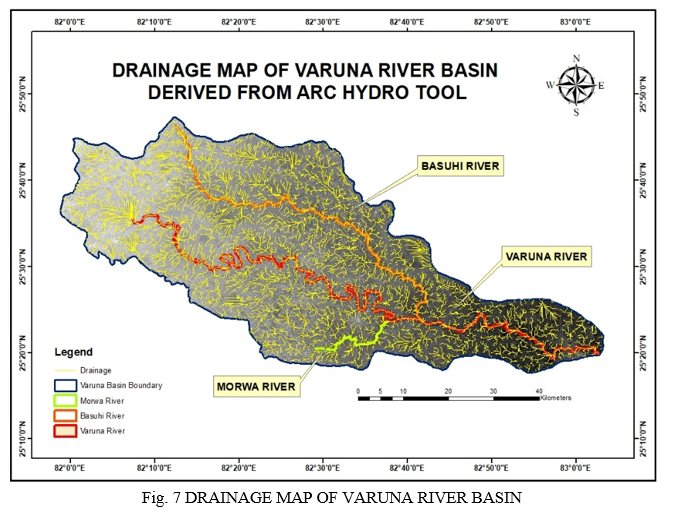
Toposheets are used to digitise Varuna River and its tributaries Basuhi & Morwa
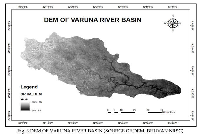
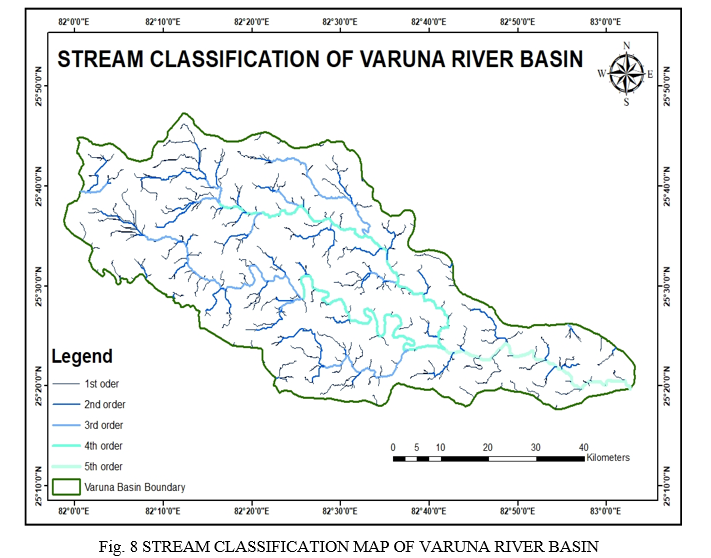
Morphometric analysis of a drainage system requires delineation of all existing streams. The stream delineation is done in GIS environment using Digital Elevation Model (DEM). Using Digital Elevation Model (DEM) data from BHUVAN- NRSC (Fig. 3) for extraction of:
- Drainage Map (Fig. 7)
- Stream Classification (Fig. 8)
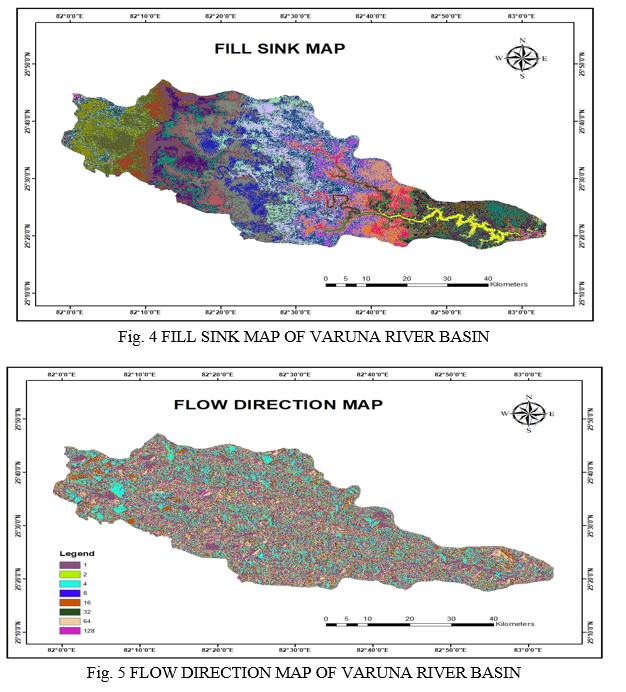
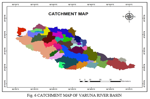
All these are derived using Arc Hydro Tool following the steps like creating fill sink map, flow direction map, catchment map etc. to get the desired result.
The morphometric parameters have been determined as per the standard methodology as shown in (Table 2)
|
Morphometric Parameters |
Formula |
References |
|
Stream order (Su) |
Hierarchical order |
Strahler,1952 |
|
Stream Length (Lu) |
Length of the stream |
Horton, 1945 |
|
Mean stream length (Lsm) |
Lsm=Lu/Nu; Where, Lu=Mean stream length of a given order (km), Nu=Number of stream segment. |
Horton, 1945 |
|
Stream length ratio (RL) |
RL= Lu / Lu-1 Where, Lu= Total stream length of order (u), Lu1=The total stream length of its next lower order |
Horton, 1945 |
|
Bifurcation Ratio (Rb) |
Rb = Nu / Nu+1 Where, Nu=Number of stream segments, present in the given order, Nu+1= Number of segments of the next higher order |
Schumm, 1956 |
|
Drainage density (Dd) |
Dd=L/A Where, L=Total length of stream, A= Area of basin |
Horton, 1945 |
|
Stream frequency (Fs) |
Fs=N/A Where, L=Total number of streams, A=Area of basin |
Horton, 1945 |
|
Texture ratio (T) |
T=N1/P Where, N1=Total number of first order stream, P=Perimeter of basin |
Horton, 1945 |
|
Form factor (Rf) |
Rf=A/(Lb)² Where, A=Area of basin, Lb=Basin length |
Horton, 1945 |
|
Elongation ratio (Re) |
Re=√(Au/π)/ Lb Where, A=Area of basin, π=3.14, Lb=Basin length |
Schumm, 1956 |
|
Circulatory ratio (Rc) |
Rc=4πA/P²Where A= Area of basin, π=3.14, P= Perimeter of basin |
Miller,1953 |
|
Length of overland flow (Lg) |
Lg=1/2Dd Where Dd= Drainage density |
Horton, 1945 |
|
Constant of channel maintenance(C) |
C=1/Dd Where, Dd= Drainage density |
Horton, 1945 |
|
Basin relief (H) |
Vertical distance between the lowest and highest points of basin |
Schumm, 1956 |
|
Relief Ratio (Rh) |
Rh = H / Lb Where, H=Basin relief, Lb=Basin length |
Schumm, 1956 |
|
Ruggedness Number (Rn) |
Rn=H×Dd Where, H= Basin relief, Dd=Drainage density |
Schumm, 1956 |
TABLE 2 FORMULA FOR COMPUTING MORPHOMETRIC PARAMETERS
V. RESULT AND DISCUSSION
A. Morphometric Analysis
Morphometry will give us mathematical measurements about basinal surface and dimension of its terrain. This will help in planning, protecting and managing Watershed in Varuna River Basin. GIS tools will help us achieving morphometric analysis. With the help of morphometric analysis we are able to gain knowledge regarding the basin geomorphology and its responses to various hydrological processes.
Remote Sensing and GIS tools like Arc GIS software are used to proceed for the development of this study.
Morphometry of Varuna River Basin
|
S.NO. |
PARAMETER |
FORMULA |
VALUE |
|
|
LINEAR
|
|
|
|
1) |
Area (A) (Km2)
|
- |
2921.43
|
|
2) |
Perimeter (P) (Km)
|
- |
308.26
|
|
3) |
Basin Length (Lb)
|
- |
173.73
|
|
4) |
Stream Order (Su) |
|
5 |
|
5) |
Stream Number (Nu)
|
N1+N2+….. NN
|
413 |
|
6) |
Stream Length (Lu) |
L1+L2+….LU
|
1290.07
|
|
7) |
Stream Frequency
|
Nu/A
|
0.141 |
|
8) |
Drainage Density (Dd)
|
Lu/A
|
0.441 |
|
9) |
Drainage Texture (Dt)
|
Nu/P
|
1.33 |
|
10) |
Bifurcation Ratio (Rb)
|
Nu/Nu+1
|
4.64 |
|
11) |
Length Of Overland Flow (Lg)
|
1/(Dd*2)
|
1.133 |
|
|
SHAPE |
|
|
|
12) |
Circularity Ratio (Rc)
|
4ΠA/(P2)
|
0.3861
|
|
13) |
Elongation Ratio (Re)
|
(2*(√A/Π))/Lb
|
0.35 |
|
14) |
Form Factor (Rf)
|
A/(Lb2)
|
0.096 |
|
15) |
Compactness Coefficient (Cc)
|
0.28*P/√A
|
1.596 |
|
16) |
Shape Factor (Sf)
|
(Lb2)/A
|
10.33 |
|
17) |
Constant Of Channel Maintenance (C) |
1/Dd
|
2.267 |
|
|
RELIEF |
|
|
|
18) |
Basin Relief (H)
|
HIGHEST-LOWEST
|
53 |
|
19) |
Relief Ratio (Rh)
|
H/Lb
|
0.30 |
Table 3 Calculated Values of Morphometric Parameters
Conclusion
Morphometry has been proved to be a very powerful tool in giving us the actual calculative parameters of the river basin. Morphometry done on the Varuna River Basin shows (in Table 3) that the calculated order of the river is 5 which tells us about the Dendritic Drainage Pattern of the basin which also indicates about the gentle slope of the area. Elongation ratio being 0.35 which shows that it is elongated telling us that it will take much more time for run off to reach the confluence. Also, bifurcation ratio measured to be 4.64 which is <5 and it means that the drainage is not controlled by any geological structures. Length of overland flow is calculated as 1.133 which is high and tells us about the gentle gradient, long flow paths, more infilteration and reduced runoff. The Drainage Density is low calculated to be 0.441 which indicates that basin has permeable soil. Low value of form factor which in 0.096 which assures us about having flatter peak flow of long duration and hence results as an elongated basin.
References
[1] Sandeep Adhikari*,1 1Central Department of Geography, Tribhuvan University, Kirtipur, Nepal (2020). Morphometric Analysis of a Drainage Basin: A Study of Ghatganga River, Bajhang District, Nepal. [2] K. Prakash, S. Singh, *C. K. Singh, A. K. Kannaujiya, P. Singh, A. Deep, And A. Gorai Department Of Geology, Bhu, Varanasi(2019). Morphometric Investigation Of Mandakini River Basin, Chitrakoot District, Uttar Pradesh, Using Remote Sensing And Gis Techniques. [3] Prakash K, Mohanty T, Pati JK, Singh S, Chaubey K (2017). Morphotectonics of the Jamini River basin, Bundelkhand Craton, Central India; using remote sensing and GIS technique. Appl Water Sci 7:3767– 3782 [4] Prakash K, Singh S, Mohanty T, Chaubey K, Singh CK (2017c) Morphometric assessment of Gomati river basin, middle Ganga plain, Uttar Pradesh, North India. Spat Inf Res 25:449–45 [5] Prakash K, Singh S, Shukla UK (2016b) Morphometric changes of the Varuna river basin, Varanasi district, Uttar Pradesh. J Geom 10:48–54. [6] Proceedings of National Conference on Open Source GIS: Opportunities and Challenges Department of Civil Engineering, IIT (BHU), Varanasi October 9-10, 2015 Planning Proposed for Varuna River Watershed using Remote Sensing and GIS Applications. [7] Mohd Iqbal and Haroon Sajjad Department of Geography, Faculty of Natural Sciences, Jamia Millia Islamia, New Delhi- 110025 India (2014). Watershed Prioritization using Morphometric and Land Use/Land Cover Parameters of Dudhganga Catchment Kashmir Valley India using Spatial Technology. [8] Altaf F, Meraj G, Romshoo AS (2013). Morphometric analysis to infer the hydrological behaviour of Lidder Watershed, Western Himalaya, India. Geography J 2013:1–14. [9] Chitra, C., Alaguraja, P., Ganeshkumari, K., Yuvaraj, D., & Manivel, M. (2011). Watershed characteristics of Kundah subbasin using remote sensing and GIS techniques. Int J Geomatics Geosci, 2(1): 311–335. [10] Ashish Pandey 1, S. Behra 2 , R.P. Pandey 3 and R.P. Singh (2011). Application of GIS for Watershed Prioritization and Management: A Case Study [11] Singh S, Singh MC (1997). Morphometric analysis of Kanhar river basin. National Geographical J of lndia 1: 31-43 [12] Strahler, A.N. (1964). Quantitative geomorphology of drainage basins and channel networks. In: Chow by VenTe (ed) Handbook of applied hydrology. New York: McGraw Hill Book Company. [13] Chow VT (1964) Handbook of applied hydrology. McGraw-Hill, New York. [14] Horton, R.E. (1945). Erosional development of streams and their drainage basins hydrophysical approach to quantitative morphology. Geological Society of America Bulletin, 56 (3), pp. 275-370. [15] Miller, V.C. (1953). A quantitative geomorphic study of drainage basin characteristics in the Clinch mountain area, Virginia and Tennessee. Columbia University, New York (3)
Copyright
Copyright © 2022 Anshika Varshney, Dr. Sudhakar Shukla. This is an open access article distributed under the Creative Commons Attribution License, which permits unrestricted use, distribution, and reproduction in any medium, provided the original work is properly cited.

Download Paper
Paper Id : IJRASET40642
Publish Date : 2022-03-05
ISSN : 2321-9653
Publisher Name : IJRASET
DOI Link : Click Here
 Submit Paper Online