

Ijraset Journal For Research in Applied Science and Engineering Technology
Simulation of Drainage System Using Storm Water Management Model (SWMM 5.1)
Authors: Dhrubajyoti Deka, Dr. Bharati Medhi Das
DOI Link: https://doi.org/10.22214/ijraset.2022.48400
Certificate: View Certificate
Abstract
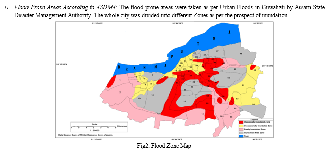
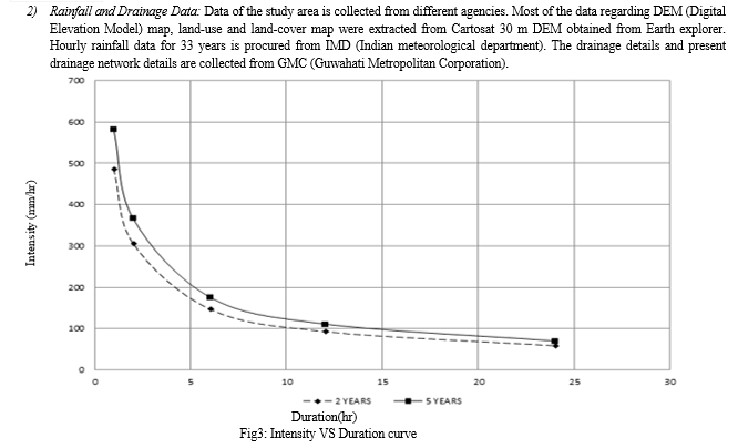
Urban flood is one of the major problems in Guwahati city at present. The topography of the city is such that rainwater cannot drain out easily from the city. With rapid growth of the city, along with people cutting and constructing houses in the surrounding hills, result in high sediment yield from the immediate upper catchment, adding another dimension to this problem. The need for a proper storm water disposal drainage system is at prime in Guwahati. Therefore innovative planning and efficient design of the drainage network is necessary. An effort has been made to study finer details of the area by investigating drainage systems of various parts of the city. The existing drainage channel is studied and simulated using SWMM 5.1 modeling software. The model is simulated for rainfall of two-year return period of interval one-hour design storm intensity. Frequency analysis is performed using best fitted distribution i.e., Gumbel’s distribution for different return periods and the frequency values are used for development of IDF (intensity-duration-frequency) curves. The city is divided into major flood prone areas according to ASDMA and then modeling is done with respect to different return period of rainfall. From simulation it is found that the existing drainage of the city is not efficient to drain out the storm-water completely, the primary cause of urban flood in Guwahati city.
Introduction
I. INTRODUCTION
The drainage system of Guwahati city is not able to drain out the massive amount of floodwater during the monsoon period. Topography of the city is such that it is difficult to have required gradient in many part of the drainage system. The outlet of the drainage system is connected to river Bharalu which is again connected to river Brahmaputra. Another problem of the drainage system is that at the time of peak flow the water level of river Bharalu rises to such a level that the water of the drainage system forms a backwater profile and the flow velocity drops almost to zero. This contributes towards sedimentation and aggravates the flood problem in the city. A sluice gate was constructed at the confluence point of the river Bharalu and Brahmaputra to prevent the backflow flow from river Brahmaputra to Bharalu and then to the city drain. It was proposed to pump out the stagnant water during the flood time. However insufficient pumping system could not solve this problem in the city.A proper drainage channel is crucial for the city. The existing drainage channel is studied and simulated using SWMM 5.1 modeling software. It is a dynamic rainfall–runoff simulation model used for single-event to continuous simulation of the surface hydrology quantity from urban or suburban areas. Sarmah Tanaya et al. (2017) reported that during monsoons, Guwahati witnesses events such as flash floods from the rivers Bharalu and Bahini tributaries of the river Brahmaputra, that cause both, casualties, and economic losses and losses to property; adversely affect the physical environment thereby affecting the bio- diversity. There is a clear need to develop both short term and long term mitigation measures. Raval S. K et al. (2018) reported that the water environment is most adversely affected by urbanization. Any type of activity in a catchment that changes the existing land use will have a direct impact on its quantity and quality characteristics. Increases in storm water runoff volumes have resulted from increasing urbanization and the accompanying growth of impervious surfaces. Up to 70% of the impervious area in urban catchments is set aside for transport (40-50% for roads). Findings from urban hydrological studies based on collection of urban hydrological data, calculations and modeling constitute a necessary fundamental for meaningful water management. Barman. P et al. (2019) reported that improper design of the sewer system leads to urban flooding in many countries. Proper design to prevent this flooding has emerged as a challenge for the engineering community. Various studies were carried out all over the world for modeling and prevention of this phenomenon.
A. Objective
- To study the existing drainage channel in the intricate urban catchment, run simulations for the existing flood water distribution network using SWMM 5.1 modeling software.
- Ensemble hydrological and hydraulic flood modeling for detail analysis of flood inundation and spatial extent of flooding in complex urban environment.
- To find out the proper size of channel required to drain out the water by running simulations in the drainage network.
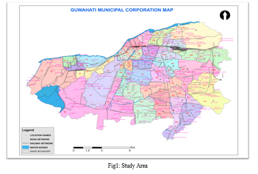
B. Study area and Data Used
Guwahati is the biggest city of the Indian state of Assam and also the largest metropolis in northeastern India. It is situated at 26.1445° N, 91.7362° E with a population of 11.2 lakhs. It is called the 'Gateway to North East India’. Dispur, the capital of Assam, is in the circuit city region located within Guwahati and is the seat of the Government of Assam. It is a major riverine port city along with hills, mountains surrounding it and one of the fastest growing cities in India, Guwahati is situated on the south bank of the Brahmaputra. The reason behind flash flood in this city is high water yield from the surrounding catchments and very high sediment yield from the upper catchments and their deposition in the drains and rivers
II. THEORY
A. Runoff Estimation
Rational Method for Estimation of Storm Water Runoff: The characteristics of drainage area such as imperviousness, topography including depressions and water pockets, shape of drainage basins and duration of rainfall determines the total runoff to be considered in the drainage system. The runoff reaching the drain is given by following formula of rational method:
Q=10CiA Where,
Q = Runoff in cu.m. / hour
C = coefficient of runoff
i = intensity of rainfall in mm/ hour
A = area of drainage basin in hectare
B. Design of Sewers
The estimated design flows depend, to a large extent, on the assumption, the accuracy of which is variable. In spite of this, care is required to select an accurate friction-flow formula as to avoid compounding errors. However, the design practice is to use the Manning’s formula for storm water drains (pipes).
Manning’s formula
V= 1/N (R2/3 S1/2)
Where,
N = Manning’s Coefficient of roughness
S = Bed slope of drainage channel
R = Hydraulic radius in meter = Area / Perimeter
V = Velocity in meter/second
Coefficient of roughness N for adopting Manning’s formula with the use of new RCC pipes with collar joints is taken as 0.012
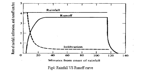
C. Horton’s Equation
Infiltration capacity of the soil rapidly declines during the early part of a storm and then tends towards a constant value after couple of hours for the remainder of the event. Horton’s equation relates infiltration capacity to initial infiltration rate (f0), and constant infiltration (fc).If the rainfall intensity at the soil surface exceeds the infiltration capacity, surface ponding (inundation) begins, and is followed by runoff over ground surface, once depression storage is filled. This runoff is called Horton’s overland flow
Horton’s equation:
f(t)=fc+(f0-fc)e –kt
fc is constant infiltration
f0 is initial infiltration rate
β is a soil parameter describing the rate of decrease of infiltration
The plot of time (t) on y-axis vs. log (f - fc) along x-axis will be a straight line
III. METHODOLOGY
The Methodology consists of three parts:
- Developing Intensity Duration Frequency (IDF) curves for the available rainfall data using best fitted distribution.
- Finding out the maximum discharge from the catchment using rational formula.
- Carrying out capacity analysis of existing drainage system for design storm intensity considered from IDF curves. Capacity analysis of existing drainage network for the chosen study area is carried out using well-known software SWMM (Storm Water Management Model). The models were set up using Cartosat 30 m DEM, geographic extracted from DEM and other drainage details collected from Guwahati Metropolitan Corporation. The total catchment area is divided into sub-basins using ArcGIS tool and according to Assam State Disaster Management Authority (ASDMA).
- Simulation of different area are done using SWMM as shown
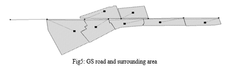
a. Map created in SWMM. The figure below is for GS road and surrounding areas
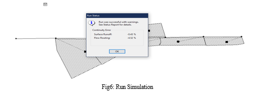
b. Run Simulation once all the data in inserted.
c. After simulation the Water elevation profile will show the areas where the drainage system is at 100% capacity and so on. 100% of capacity is showing flood.
A. For GS road and Surrounding Area
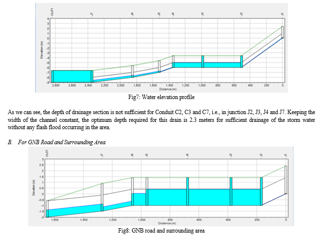
As we can see, the depth of drainage section is not sufficient for Conduit C2, C3 and C4, i.e., in junction J2, J3, J4 and J5. Keeping the width of the channel constant, the optimum depth required for this drain is 2.4 meters for sufficient drainage of the storm water without any flash flood occurring in the area.
Conclusion
The drainage system of Guwahati city is not satisfactory as it cannot drain out floodwater during the monsoon period. The depth which is currently provided in most of the major drains ranges from 1m to 2.5m. The drains having 1m depth is nowhere near safe from a flash flood point of view. Having more than 2 meters of depth is satisfactory but in most of the drains lesser depth is provided, which again decreases due to heavy sedimentation from the surrounding hills. After simulation for most of the area, required depth is found out to be more than 2 meters. For GNB road with current depth 1.4 meters required depth is 2.4 meters and for GS road with current depth 1meter required depth is 2.3 meters. We can change the width of the channel to have a greater cross sectional area. But in the field it is not possible as it will decrease the road width, which is not a favorable outcome. Topography of the city is such that it is very difficult to have required gradient in many part of the drainage system. But if we can keep the bed slope uniformly sloped at least between two junctions, even having a very less slope will result in smooth drainage of the storm water.
References
[1] S.K.Raval (2018). Storm Water Drainage Solutions for Urban Area. [2] Barman P, Sarma B, Sarma A.K (2019). A study on flood hazard mitigation of Guwahati city. [3] Bapalu, G.Venkata and Rajiv Sinha (2005). GIS in Flood Hazard Mapping: A Case Study of Kosi River Basin, India, GIS Development. [4] Flood Estimation Report for south Brahmaputra subzone- 2(b), Central Water Commission. [5] Ecological and Energy Efficient Practices for Storm Water Management, Guwahati, Assam. C-GINS [6] Vedas research group (VRG) Urban Flood Water Management by Gaurav Jain content generation & disse-mination division (CGDD) EPSA. [7] Monitoring and Mapping of Flash Flood of Patna City Using Sentinel-1 Images: A Case of India’s Most Flood Prone State Tasneem Ahmed, Department of Computer Application Integral University,Lucknow, Uttar Pradesh-India-226026 [8] Simulation of Urban Drainage System Using a Storm Water Management Model (SWMM) [9] Vinay Ashok Rangari1, Sriramoju Sai Prashanth, N. V. Umamahesh and Ajey Kumar Patel Research Scholar, Graduate Student, Professor, Assistant Professor, National Institute of Technology, Warangal, Andhra Pradesh, India. [10] Urban Flood Scaling Using Hydrologic and Hydraulic Models with Inception for Early Warning by Romeji Ngangbam, Amaljit Bharali, and Sonamani Kangjam. [11] Policy and Design Criteria Manual for Surface Water Management Prepared by O CH2MHlLL [12] Unplanned urban growth: land use/land cover change in the Guwahati Metropolitan Area, India. By Chandra Kant Pawe & Anup Saikia. Article in Geografisk tidskrift / udgivet af Bestyrelsen for Det Kongelige danske geografiske selskab.
Copyright
Copyright © 2022 Dhrubajyoti Deka, Dr. Bharati Medhi Das. This is an open access article distributed under the Creative Commons Attribution License, which permits unrestricted use, distribution, and reproduction in any medium, provided the original work is properly cited.

Download Paper
Paper Id : IJRASET48400
Publish Date : 2022-12-26
ISSN : 2321-9653
Publisher Name : IJRASET
DOI Link : Click Here
 Submit Paper Online